IMAGES TAKEN NEAR TO
Thorneloe Road, WORCESTER, WR1 3HZ
Introduction
This page details the photographs taken nearby to Thorneloe Road, WR1 3HZ by members of the Geograph project.
The Geograph project started in 2005 with the aim of publishing, organising and preserving representative images for every square kilometre of Great Britain, Ireland and the Isle of Man.

There are currently over 7.5m images from over14,400 individuals and you can help contribute to the project by visiting https://www.geograph.org.uk
Image Map
Images are licensed for reuse under creativecommons.org/licenses/by-sa/2.0
Notes
- Clicking on the map will re-center to the selected point.
- The higher the marker number, the further away the image location is from the centre of the postcode.
Image Listing (98 Images Found)
Images are licensed for reuse under creativecommons.org/licenses/by-sa/2.0
Image
Details
Distance
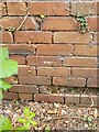
1

Ordnance Survey Bench mark
Bench Mark located on wall, north-west side of Thorneloe Road, Worcester. These marks were used by Ordnance Survey for mapping purposes.
Image: © V1ncenze
Taken: 15 Jul 2020
0.07 miles
2
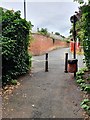
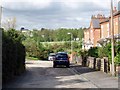
Thorneloe Walk, Worcester
View from Thorneloe Walk, Worcester onto Thorneloe Road.
Image: © V1ncenze
Taken: 15 Jul 2020
0.07 miles
3
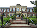
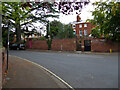
Francis Court (retirement living), Worcester
This retirement property includes a former school building as seen here with Worcester's coat of arms above the door.
Image: © Chris Allen
Taken: 16 Aug 2021
0.09 miles
4
Ordnance Survey Bench Mark
This mark is located on an old outbuilding on Stephenson Road, Worcester. These marks were used by Ordnance survey for mapping purposes.
Image: © V1ncenze
Taken: 15 Jul 2020
0.09 miles
5
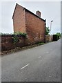
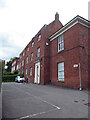
Building, Stephenson Road, Worcester
Old outbuilding located on South West side of Stephenson Road Worcester. An Ordnance Survey bench mark is also present on the wall.
Image: © V1ncenze
Taken: 15 Jul 2020
0.09 miles
6
Selbourne Road West with a view of Worcester race course
Image: © Norman Caesar
Taken: 12 May 2012
0.10 miles
7

School of Art and Design, Barbourne Road
Image: © Norman Caesar
Taken: 12 May 2012
0.10 miles
9
Thorneloe Lodge Surgery, Worcester
Although familiar with the names of Worcester's GP surgeries, I am only just beginning to discover their locations while exploring the city on foot. Many are in newer buildings but not this one.
Image: © Chris Allen
Taken: 16 Aug 2021
0.11 miles
10
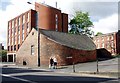
A strange shaped building on Barbourne Road.
This building may have been connected to the brewery that has been knocked down and is now a block of flats
Image: © Norman Caesar
Taken: 12 May 2012
0.12 miles