1
Thorneloe Walk, Worcester
View from Thorneloe Walk, Worcester onto Thorneloe Road.
Image: © V1ncenze
Taken: 15 Jul 2020
0.06 miles
2
Ordnance Survey Bench mark
Bench Mark located on wall, north-west side of Thorneloe Road, Worcester. These marks were used by Ordnance Survey for mapping purposes.
Image: © V1ncenze
Taken: 15 Jul 2020
0.06 miles
3
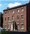
Old Baskerville, Barbourne Road, Worcester
A stately late C18th house set back from the street and still retaining modest grounds. Excellent proportions, the central bay spaced more widely. Each window has a fluted keystone and it boasts a handsome porch (
Image]). Grade II listed.
Image: © Stephen Richards
Taken: 17 Jul 2014
0.06 miles
4
Detail of Old Baskerville, Barbourne Road, Worcester
Handsome Ionic porch decorated with swags.
Wider view:
Image
Image: © Stephen Richards
Taken: 17 Jul 2014
0.06 miles
5
Old Baskerville, Worcester
A Grade II Listed former country house that is now flats.
Image: © Chris Allen
Taken: 16 Aug 2021
0.06 miles
6
33-63 York Place, Worcester
Dated 1831-35, although more Victorian in character.
Image: © Stephen Richards
Taken: 15 Jul 2014
0.06 miles
7
Paradise House, Brewery Walk, Worcester
Early C19th house. A wing extends at right angles behind. Grade II listed.
Now flats.
Image: © Stephen Richards
Taken: 17 Jul 2014
0.07 miles
8
Kwik-Fit, Barbourne Road, Worcester
Image: © Chris Allen
Taken: 16 Aug 2021
0.07 miles
9
An unusual building on Barbourne Road, Worcester
This unusual building nearest to the camera is Grade II Listed and stated to be possibly a former horse engine house for a water pump. c1850 with possibly earlier origins (c1830). Thought to be possibly associated with Spreckley's Brewery that has been demolished apart from a former malting that is now housing. Not something you expect to see so near the city centre.
Image: © Chris Allen
Taken: 16 Aug 2021
0.09 miles
10
Traffic and offices, Barbourne Road, Worcester
Image: © Peter Barr
Taken: 3 Feb 2012
0.09 miles


