IMAGES TAKEN NEAR TO
Barbourne Lane, WORCESTER, WR1 3ET
Introduction
This page details the photographs taken nearby to Barbourne Lane, WR1 3ET by members of the Geograph project.
The Geograph project started in 2005 with the aim of publishing, organising and preserving representative images for every square kilometre of Great Britain, Ireland and the Isle of Man.

There are currently over 7.5m images from over14,400 individuals and you can help contribute to the project by visiting https://www.geograph.org.uk
Image Map (Loading...)


Getting Data...Please wait
Leaflet Map data © OpenStreetMap
Images are licensed for reuse under creativecommons.org/licenses/by-sa/2.0
Notes
- Clicking on the map will re-center to the selected point.
- The higher the marker number, the further away the image location is from the centre of the postcode.
Image Listing (128 Images Found)
Images are licensed for reuse under creativecommons.org/licenses/by-sa/2.0
Image
Details
Distance
1
Barbourne Brook and playground, Gheluvelt Park, Worcester
Image: © Jeff Gogarty
Taken: 25 Apr 2023
0.03 miles
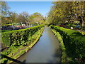
2
Barbourne Brook in Gheluvelt Park, Worcester
Image: © Chris Allen
Taken: 16 Aug 2021
0.03 miles
3
Swan on Barbourne Brook, Gheluvelt Park, Worcester
Image: © Jeff Gogarty
Taken: 25 Apr 2023
0.04 miles
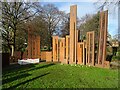
4
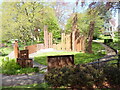
Battle of Gheluvelt: Interpretive Feature
This unique installation commemorates WWI and particularly the Battle of Gheluvelt near Ypres, Belgium.
Image: © Jeff Gogarty
Taken: 25 Apr 2023
0.04 miles
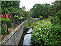
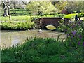
5
Bridge on Ombersley Rd, Worcester
Bridge over small stream. Located on Ombersley Road, Worcester. North west side of road.
Image: © V1ncenze
Taken: 10 Oct 2019
0.04 miles
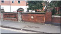
8
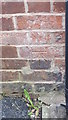
Ordnance Survey cut mark
Cut mark located on wall of 39 Barbourne Lane, Worcester. These marks were used by Ordnance Survey for mapping purposes.
Image: © V1ncenze
Taken: 10 Oct 2019
0.04 miles
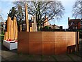
9
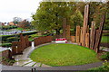
War memorial in Gheluvelt Park
The height of the columns represents the casualties through the course of WW1.
Image: © Bill Boaden
Taken: 2 Nov 2014
0.04 miles
10
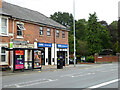
Shops and Gheluvelt Park on Barbourne road, Worcester
The road is the A38 towards Droitwich.
Image: © Chris Allen
Taken: 16 Aug 2021
0.04 miles