IMAGES TAKEN NEAR TO
York Place, WORCESTER, WR1 3DR
Introduction
This page details the photographs taken nearby to York Place, WR1 3DR by members of the Geograph project.
The Geograph project started in 2005 with the aim of publishing, organising and preserving representative images for every square kilometre of Great Britain, Ireland and the Isle of Man.

There are currently over 7.5m images from over14,400 individuals and you can help contribute to the project by visiting https://www.geograph.org.uk
Image Map
Images are licensed for reuse under creativecommons.org/licenses/by-sa/2.0
Notes
- Clicking on the map will re-center to the selected point.
- The higher the marker number, the further away the image location is from the centre of the postcode.
Image Listing (106 Images Found)
Images are licensed for reuse under creativecommons.org/licenses/by-sa/2.0
Image
Details
Distance
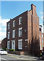
1

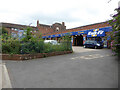
33-63 York Place, Worcester
Dated 1831-35, although more Victorian in character.
Image: © Stephen Richards
Taken: 15 Jul 2014
0.02 miles
2
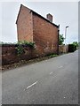
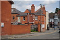
Building, Stephenson Road, Worcester
Old outbuilding located on South West side of Stephenson Road Worcester. An Ordnance Survey bench mark is also present on the wall.
Image: © V1ncenze
Taken: 15 Jul 2020
0.10 miles
3
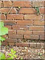
Ordnance Survey Bench Mark
This mark is located on an old outbuilding on Stephenson Road, Worcester. These marks were used by Ordnance survey for mapping purposes.
Image: © V1ncenze
Taken: 15 Jul 2020
0.10 miles
4
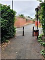
Thorneloe Walk, Worcester
View from Thorneloe Walk, Worcester onto Thorneloe Road.
Image: © V1ncenze
Taken: 15 Jul 2020
0.10 miles
5

Ordnance Survey Bench mark
Bench Mark located on wall, north-west side of Thorneloe Road, Worcester. These marks were used by Ordnance Survey for mapping purposes.
Image: © V1ncenze
Taken: 15 Jul 2020
0.10 miles
6
Paradise House, Brewery Walk, Worcester
Early C19th house. A wing extends at right angles behind. Grade II listed.
Now flats.
Image: © Stephen Richards
Taken: 17 Jul 2014
0.11 miles
8
Hebb Street, Rear of Paradise Row
Typical Worcester red brick at the rear of the shops in Paradise Row.
Image: © Peter Young
Taken: 15 Jun 2015
0.11 miles
9
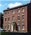
Old Baskerville, Barbourne Road, Worcester
A stately late C18th house set back from the street and still retaining modest grounds. Excellent proportions, the central bay spaced more widely. Each window has a fluted keystone and it boasts a handsome porch (Image]). Grade II listed.
Image: © Stephen Richards
Taken: 17 Jul 2014
0.11 miles
10
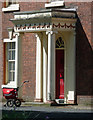
Detail of Old Baskerville, Barbourne Road, Worcester
Handsome Ionic porch decorated with swags.
Wider view: Image
Image: © Stephen Richards
Taken: 17 Jul 2014
0.11 miles