IMAGES TAKEN NEAR TO
Station Yard Industrial Estate, MALVERN, WR13 6RN
Introduction
This page details the photographs taken nearby to Station Yard Industrial Estate, WR13 6RN by members of the Geograph project.
The Geograph project started in 2005 with the aim of publishing, organising and preserving representative images for every square kilometre of Great Britain, Ireland and the Isle of Man.

There are currently over 7.5m images from over14,400 individuals and you can help contribute to the project by visiting https://www.geograph.org.uk
Image Map
Images are licensed for reuse under creativecommons.org/licenses/by-sa/2.0
Notes
- Clicking on the map will re-center to the selected point.
- The higher the marker number, the further away the image location is from the centre of the postcode.
Image Listing (148 Images Found)
Images are licensed for reuse under creativecommons.org/licenses/by-sa/2.0
Image
Details
Distance
1
Schweppes Malvern Water bottling plant, Colwall
Schweppes moved their Malvern Water operations from the Holy Well in Malvern Wells to this bottling plant in the 1890s.
The building on the right with the pyramidal white tower was designed to look very similar to the Holy Well building.
This plant has now ceased operation and the site will be redeveloped.
Bottling has restarted at the original Holy Well site by the latest owners.
Image: © Bob Embleton
Taken: 29 Mar 2012
0.03 miles
2

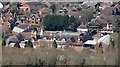
Primeswell Close, Colwall
Recently-built housing in the popular commuter village of Colwall.
Malvern Hills beyond.
Image: © Jonathan Billinger
Taken: 9 Dec 2019
0.03 miles
3
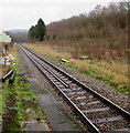
Railway from Colwall towards Great Malvern
Viewed from the NE end of the single platform Colwall railway station in eastern Herefordshire.
Next station ahead is Great Malvern in the west of Worcestershire.
Image: © Jaggery
Taken: 11 Jan 2016
0.05 miles
4
Bench and bus stop, Colwall
Alongside the B4218 Walwyn Road near the corner of Oak Drive.
Image: © Jaggery
Taken: 11 Jan 2016
0.07 miles
5
Schweppes electricity substation, Colwall
The Western Power Distribution electricity substation is between the tree
and the black & white house, on the southeast side of the B4218 Walwyn Road.
The substation identifier is Schweppes. This location is near the Malvern Water Bottling Works (closed down at the January 2016 date of this photo) which were built by Schweppes in 1892 next to the Great Western Railway line so that empty bottles could be easily transported to the site, and full bottles taken away.
A notice on the substation shows the presence of SF6 (sulphur hexafluoride, an insulating gas used in high voltage systems)
Image: © Jaggery
Taken: 11 Jan 2016
0.07 miles
6
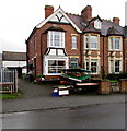
Peter's fruit & veg shop, Colwall
Greengrocery at 1 Brighton Villa, Walwyn Road.
Image: © Jaggery
Taken: 11 Jan 2016
0.07 miles
7
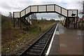
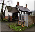
Colwall Station
The footbridge over the single track railway at Colwall Station.
Image: © Philip Halling
Taken: 13 Apr 2008
0.08 miles
8
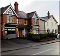
Chester House, Colwall
Viewed across the B4218 Walwyn Road in January 2016 when the name Chester House is on the shop on the left. A May 2011 Google Earth Street View shows the name Classic Interiors here.
Provisions of Colwall http://www.geograph.org.uk/photo/4989734 is next door.
Image: © Jaggery
Taken: 11 Jan 2016
0.08 miles
9
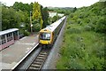
Train in Colwall Station
A West Midlands Train in Colwall Station.
Image: © Philip Halling
Taken: 20 May 2022
0.09 miles
10
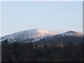
Worcestershire Beacon from Colwall
Worcestershire Beacon taken from the railway footbridge at Colwall Station, just before sunrise
Image: © Steve Stratton
Taken: 2 Jan 2010
0.09 miles