IMAGES TAKEN NEAR TO
Pedlingham Close, MALVERN, WR13 6RB
Introduction
This page details the photographs taken nearby to Pedlingham Close, WR13 6RB by members of the Geograph project.
The Geograph project started in 2005 with the aim of publishing, organising and preserving representative images for every square kilometre of Great Britain, Ireland and the Isle of Man.

There are currently over 7.5m images from over14,400 individuals and you can help contribute to the project by visiting https://www.geograph.org.uk
Image Map
Images are licensed for reuse under creativecommons.org/licenses/by-sa/2.0
Notes
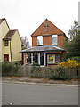
- Clicking on the map will re-center to the selected point.
- The higher the marker number, the further away the image location is from the centre of the postcode.
Image Listing (143 Images Found)
Images are licensed for reuse under creativecommons.org/licenses/by-sa/2.0
Image
Details
Distance
1
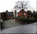
Hazel Bank, Colwall
Modern detached house viewed across Old Church Road.
Image: © Jaggery
Taken: 11 Jan 2016
0.07 miles
2
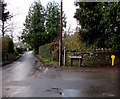
Junction of Old Church Road and Mathon Road, Colwall
Mathon Road on the right leads to the Herefordshire village of Mathon Image 5 km (3 miles) away.
Image: © Jaggery
Taken: 11 Jan 2016
0.07 miles
3
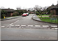
Oak Drive, Colwall
Viewed across the B4218 Walwyn Road.
Image: © Jaggery
Taken: 11 Jan 2016
0.08 miles
4

Stone Drive houses, Colwall
Stone Drive extends from Walwyn Road 70 metres behind the camera to Old Church Road 300 metres ahead.
Image: © Jaggery
Taken: 11 Jan 2016
0.08 miles
5
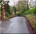
End of the 30 zone, Mathon Road, Colwall
About 20 metres north of the Old Church Road junction http://www.geograph.org.uk/photo/4792127 the 30mph speed limit increases
to the National Speed Limit. A red-edged triangular sign warns of a narrower road ahead.
Image: © Jaggery
Taken: 11 Jan 2016
0.09 miles
6
Southern end of Mathon Road, Colwall
Viewed from near the Old Church Road junction. http://www.geograph.org.uk/photo/4792127
Mathon Road heads towards the Herefordshire village of Mathon Image 5 km (3 miles) away.
Image: © Jaggery
Taken: 11 Jan 2016
0.10 miles
7
Colwall Free Church
Walwyn Road, Colwall Stone.
Image: © Pauline E
Taken: 21 Nov 2008
0.10 miles
8

Stone Drive houses, Colwall
Nearest the camera are Aristea Cottage and Bergen Cottage.
Image: © Jaggery
Taken: 11 Jan 2016
0.10 miles
9

Old Library Lodge B&B, Colwall
Bed & breakfast accommodation at 1A Stone Drive.
Image: © Jaggery
Taken: 11 Jan 2016
0.11 miles
10
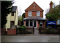
Colwall Community Church, Colwall
Viewed across the B4218 Walwyn Road. The church's website states that the church is part of the Salt and Light family of churches – a network of churches across the UK that share common values and collaborate in various initiatives.
Colwall grew up around the railway station which opened in 1861 on the line from Hereford to Worcester.
The church has its roots in a Sunday School class set up for the benefit of the railway workers' children at the time the line was being laid.
Image: © Jaggery
Taken: 11 Jan 2016
0.12 miles