IMAGES TAKEN NEAR TO
Harbour Drive, MALVERN, WR13 6QF
Introduction
This page details the photographs taken nearby to Harbour Drive, WR13 6QF by members of the Geograph project.
The Geograph project started in 2005 with the aim of publishing, organising and preserving representative images for every square kilometre of Great Britain, Ireland and the Isle of Man.

There are currently over 7.5m images from over14,400 individuals and you can help contribute to the project by visiting https://www.geograph.org.uk
Image Map
Images are licensed for reuse under creativecommons.org/licenses/by-sa/2.0
Notes
- Clicking on the map will re-center to the selected point.
- The higher the marker number, the further away the image location is from the centre of the postcode.
Image Listing (139 Images Found)
Images are licensed for reuse under creativecommons.org/licenses/by-sa/2.0
Image
Details
Distance
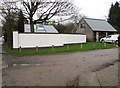
1
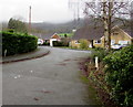
Harbour Drive, Colwall
Cul-de-sac on the east side of the B4218 Walwyn Road.
A nearby notice states that this is a private road - access to frontages only.
Image: © Jaggery
Taken: 11 Jan 2016
0.02 miles
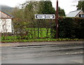
2
Direction and distances sign, Colwall
Pointing across the B4218 Walwyn Road towards Old Church Road, the sign shows Cradley 4 (miles), Mathon 3.
Image: © Jaggery
Taken: 11 Jan 2016
0.03 miles
3
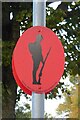
Remembrance Tommy Lamp post signs
One of a number of Remembrance Tommy lamp post signs in Colwall.
Image: © Philip Halling
Taken: 26 Oct 2023
0.04 miles
5
Plum Tree House, Colwall
Recently-built house on the east side of the B4218 Walwyn Road, viewed in January 2016.
Image: © Jaggery
Taken: 11 Jan 2016
0.05 miles
6
B4218 distances from Colwall
The sign facing Old Church Road shows Malvern 2 (miles) to the left, Ledbury 5 to the right.
Image: © Jaggery
Taken: 11 Jan 2016
0.05 miles
7
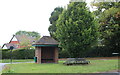
Bus shelter, Mathon Turn, Colwall
Back in 1951 (60 years ago) the Colwall Bus Shelters Committee was busy getting plans approved for three bus shelters: at "Mathon Turn", "The Stone" and this one at "Colwall Green".
It had been agreed that "..they are to be built of hand-made sand faced bricks with old hand-made tiled roofs, gabled with bull's-eye windows in the first two, and larger front windows in the one at the Green".
As one can see the "bull's-eye window" was dropped from the final plans (though the Colwall Green bus shelter does indeed have windows -at the front with a narrower opening).
The shelter at Colwall Stone has been replaced with a modern garish metal and plastic affair, probably as part of a recent building program in that area.
Image]
Image]
Image: © Bob Embleton
Taken: 9 Sep 2011
0.05 miles
8
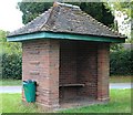
Mathon Turn bus shelter, Colwall
Back in 1951 (60 years ago) the Colwall Bus Shelters Committee was busy getting plans approved for three bus shelters.
It had been agreed that "..they are to be built of hand-made sand faced bricks with old hand-made tiled roofs, gabled with bull's-eye windows.."
As one can see the "bull's-eye window" was dropped from the final plans.
Image]
Image: © Bob Embleton
Taken: 9 Sep 2011
0.05 miles
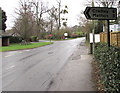
9
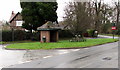
Bus shelter and benches on a grass triangle, Colwall
The roughly triangular grassy area is at a three-way junction -
the B4218 Walwyn Road on the camera side, Old Church Road and Brockhill Road
Image: © Jaggery
Taken: 11 Jan 2016
0.05 miles
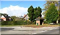
10
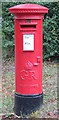
Postbox, Mathon Turn, Colwall
A George V postbox on the corner of Brockhill Road and Walwyn Road.
Image]
Image: © Bob Embleton
Taken: 9 Sep 2011
0.06 miles