IMAGES TAKEN NEAR TO
Hanley Road, MALVERN, WR13 6NP
Introduction
This page details the photographs taken nearby to Hanley Road, WR13 6NP by members of the Geograph project.
The Geograph project started in 2005 with the aim of publishing, organising and preserving representative images for every square kilometre of Great Britain, Ireland and the Isle of Man.

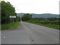
There are currently over 7.5m images from over14,400 individuals and you can help contribute to the project by visiting https://www.geograph.org.uk
Image Map
Images are licensed for reuse under creativecommons.org/licenses/by-sa/2.0
Notes
- Clicking on the map will re-center to the selected point.
- The higher the marker number, the further away the image location is from the centre of the postcode.
Image Listing (26 Images Found)
Images are licensed for reuse under creativecommons.org/licenses/by-sa/2.0
Image
Details
Distance
1
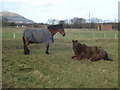
Stud farm horses
This part of Hill View Stud Farm was once an army camp. North Hill and Great Malvern in the distance to the north-west.
Image: © Trevor Rickard
Taken: 29 Dec 2007
0.02 miles
2
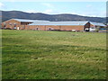
Old army camp near Hanley Swan
View westwards with the Malverns behind. This old army camp was dismantled after the war and is now used by industrial units and the stud farm. A genuine narrow boat undergoing repairs to the right - possibly being launched at Upton Marina, five miles away.
Image: © Trevor Rickard
Taken: 29 Dec 2007
0.07 miles
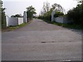
3
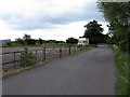
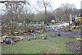
Merebrook Business Park
Not much business being done. My map shows this as a former camping ground, but there's no evidence on the ground.
Image: © Peter Whatley
Taken: 6 Jun 2008
0.08 miles
4
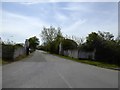
Entrance to Merebrook Camp
One of five army hospital sites around Malvern built for the US Army in 1942-44. However, this camp also had explosives stores, which were still visible in the 1960s. The British Army used it until the mid 1950s
Image: © David Smith
Taken: 6 May 2016
0.11 miles
5
Hanley Road at Merebrook Business Park
Looking back towards Malvern Wells
Image: © Peter Whatley
Taken: 6 Jun 2008
0.14 miles
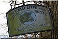
6
Entrance to War Time Camp
Several army camps were built around the Malverns many were D Day hospitals, but this one, I was told, was the original camp for the SAS.
Image: © Bob Embleton
Taken: 24 Apr 2005
0.14 miles
7
Friesian sign, Common Farm
On the B4209 outside Common Farm.
Image: © Bob Embleton
Taken: 8 Feb 2009
0.15 miles
8
Common Farm
Adjacent to the B4209 near Hanley Swan.
Image: © Jonathan Billinger
Taken: 21 Jul 2014
0.15 miles
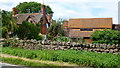
9
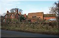
Common Farm
A Victorian looking farmhouse with lovely barns and out buildings beside the B4209.
Image: © Bob Embleton
Taken: 8 Feb 2009
0.16 miles
10
Guinea Fowl, rear of Common Farm
On the path to Blackmore Wood.
Image: © Bob Embleton
Taken: 8 Feb 2009
0.16 miles