IMAGES TAKEN NEAR TO
Netherley Lane, MALVERN, WR13 6JL
Introduction
This page details the photographs taken nearby to Netherley Lane, WR13 6JL by members of the Geograph project.
The Geograph project started in 2005 with the aim of publishing, organising and preserving representative images for every square kilometre of Great Britain, Ireland and the Isle of Man.

There are currently over 7.5m images from over14,400 individuals and you can help contribute to the project by visiting https://www.geograph.org.uk
Image Map
Images are licensed for reuse under creativecommons.org/licenses/by-sa/2.0
Notes
- Clicking on the map will re-center to the selected point.
- The higher the marker number, the further away the image location is from the centre of the postcode.
Image Listing (4 Images Found)
Images are licensed for reuse under creativecommons.org/licenses/by-sa/2.0
Image
Details
Distance
1
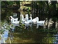
Geese on a pond
Geese on a pond beside Netherley Lane at Berrow.
Image: © Philip Halling
Taken: 13 Oct 2020
0.03 miles
2
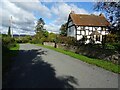
Timber-framed farmhouse
Hayes Farm, a timber-framed farmhouse Grade II listed building, see: https://historicengland.org.uk/listing/the-list/list-entry/1156343
Image: © Philip Halling
Taken: 13 Oct 2020
0.08 miles
4
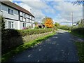
Cottage on Netherley Lane
Cottage on Netherley Lane near Berrow.
Image: © Philip Halling
Taken: 13 Oct 2020
0.13 miles