IMAGES TAKEN NEAR TO
Gloucester Road, MALVERN, WR13 6BS
Introduction
This page details the photographs taken nearby to Gloucester Road, WR13 6BS by members of the Geograph project.
The Geograph project started in 2005 with the aim of publishing, organising and preserving representative images for every square kilometre of Great Britain, Ireland and the Isle of Man.

There are currently over 7.5m images from over14,400 individuals and you can help contribute to the project by visiting https://www.geograph.org.uk
Image Map
Images are licensed for reuse under creativecommons.org/licenses/by-sa/2.0
Notes
- Clicking on the map will re-center to the selected point.
- The higher the marker number, the further away the image location is from the centre of the postcode.
Image Listing (19 Images Found)
Images are licensed for reuse under creativecommons.org/licenses/by-sa/2.0
Image
Details
Distance
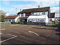
1
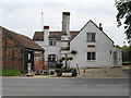
Robin Hood pub, near Chandler's Cross
Image: © Peter Whatley
Taken: 30 May 2008
0.05 miles
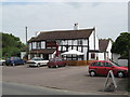
2
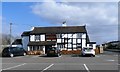
The Robin Hood following its facelift
Still retains character but with a new tarmac car park, fencing and tables. At the back is the caravan site for those who want a 'get away from it all' break.
Image: © Trevor Rickard
Taken: 22 May 2007
0.05 miles
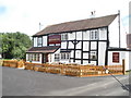
3
The Robin Hood
The Robin Hood Inn on the B4208 at Castlemorton.
Image: © Philip Halling
Taken: 19 Nov 2020
0.06 miles
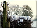
9
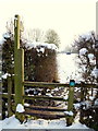
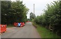
Snowy footpath
Leading south from New Road, Castlemorton.
Image: © Jonathan Billinger
Taken: 24 Jan 2013
0.22 miles