IMAGES TAKEN NEAR TO
Smiths Green, MALVERN, WR13 5PE
Introduction
This page details the photographs taken nearby to Smiths Green, WR13 5PE by members of the Geograph project.
The Geograph project started in 2005 with the aim of publishing, organising and preserving representative images for every square kilometre of Great Britain, Ireland and the Isle of Man.

There are currently over 7.5m images from over14,400 individuals and you can help contribute to the project by visiting https://www.geograph.org.uk
Image Map (Loading...)


Getting Data...Please wait
Leaflet Map data © OpenStreetMap
Images are licensed for reuse under creativecommons.org/licenses/by-sa/2.0
Notes
- Clicking on the map will re-center to the selected point.
- The higher the marker number, the further away the image location is from the centre of the postcode.
Image Listing (22 Images Found)
Images are licensed for reuse under creativecommons.org/licenses/by-sa/2.0
Image
Details
Distance
1
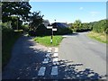
Road junction at Weobley Cross
The road on the left is a no through road providing access to a farm and dwellings.
Image: © Philip Halling
Taken: 9 Sep 2020
0.08 miles
2
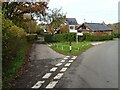
Road junction at Weobley Cross
Road junction at Weobley Cross near Mathon. The road on the left is a no through road.
Image: © Philip Halling
Taken: 5 Nov 2020
0.09 miles
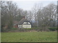
3
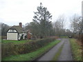
Cottage at Smith's Green
Looking westwards with the entrance to Perry Mill on the right fork.
Image: © Trevor Rickard
Taken: 13 Dec 2007
0.12 miles
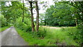
4
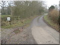
Lane at Smith's Green
View westwards with two signs to the left - the public footpath marker post and the sign for the caravan and camping site - a good place to get away from it all!
Image: © Trevor Rickard
Taken: 13 Dec 2007
0.12 miles
5
Cottage at Smith's Green
View westwards from the public footpath to an attractive 'black-and-white' cottage.
Image: © Trevor Rickard
Taken: 13 Dec 2007
0.13 miles
6
Cottage at Smith's Green
Cottage at Smith's Green viewed from the footpath to Colwall Stone.
Image: © Philip Halling
Taken: 13 Apr 2008
0.15 miles
7
South Hyde Lane
Looking east towards Ham Green; woodland and ponds to the right.
Image: © Jonathan Billinger
Taken: 8 Jul 2014
0.17 miles
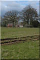
9
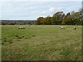
Field of sheep
Field of sheep near Mathon.
Image: © Philip Halling
Taken: 5 Nov 2020
0.17 miles
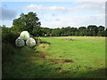
10
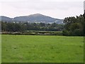
The fields of Burfords Farm
Looking south towards "British Camp" (Herefordshire Beacon) on the Malvern Hills
Image: © Bob Embleton
Taken: 4 Aug 2005
0.19 miles