IMAGES TAKEN NEAR TO
Cradley, MALVERN, WR13 5NR
Introduction
This page details the photographs taken nearby to WR13 5NR by members of the Geograph project.
The Geograph project started in 2005 with the aim of publishing, organising and preserving representative images for every square kilometre of Great Britain, Ireland and the Isle of Man.

There are currently over 7.5m images from over14,400 individuals and you can help contribute to the project by visiting https://www.geograph.org.uk
Image Map
Images are licensed for reuse under creativecommons.org/licenses/by-sa/2.0
Notes
- Clicking on the map will re-center to the selected point.
- The higher the marker number, the further away the image location is from the centre of the postcode.
Image Listing (9 Images Found)
Images are licensed for reuse under creativecommons.org/licenses/by-sa/2.0
Image
Details
Distance
1
Grittlesend - Stone House
A remarkable design on the side of Winthill Farm hill, built, unsurprisingly, with stone facings.
Image: © Peter Whatley
Taken: 4 Jun 2008
0.01 miles
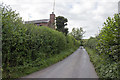
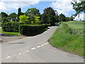
3
Lane to Suckley
The hamlet of Grittlesend, Herefordshire.
Image: © Jonathan Billinger
Taken: 14 Nov 2014
0.03 miles
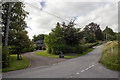
4
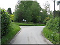
Grittlesend - the junction
Cradley to the left; Suckley to the right.
Image: © Peter Whatley
Taken: 4 Jun 2008
0.03 miles
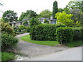
5
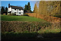
Cottage at Grittlesend
Half-timbered black and white cottage at Grittlesend.
Image: © Philip Halling
Taken: 28 Dec 2008
0.05 miles
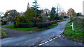
7
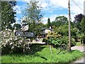
Grittlesend Hamlet
With Stone House visible behind the road sign.
Image: © Bob Embleton
Taken: 3 Aug 2005
0.14 miles
8
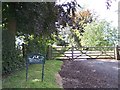
Entrance gates to Winthill Farm
At the top of the hill above Grittlesend.
Image: © Bob Embleton
Taken: 3 Aug 2005
0.14 miles