IMAGES TAKEN NEAR TO
Ridgeway Cross, MALVERN, WR13 5JJ
Introduction
This page details the photographs taken nearby to Ridgeway Cross, WR13 5JJ by members of the Geograph project.
The Geograph project started in 2005 with the aim of publishing, organising and preserving representative images for every square kilometre of Great Britain, Ireland and the Isle of Man.

There are currently over 7.5m images from over14,400 individuals and you can help contribute to the project by visiting https://www.geograph.org.uk
Image Map
Images are licensed for reuse under creativecommons.org/licenses/by-sa/2.0
Notes
- Clicking on the map will re-center to the selected point.
- The higher the marker number, the further away the image location is from the centre of the postcode.
Image Listing (9 Images Found)
Images are licensed for reuse under creativecommons.org/licenses/by-sa/2.0
Image
Details
Distance
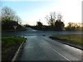
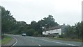
2
Chockbury Road junction
Onto the A4103.
Image: © Oast House Archive
Taken: 17 Aug 2013
0.20 miles
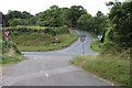
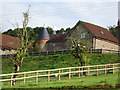
4
Tanhouse Farm, Ridgeway Cross
Viewed from the north on Tanhouse Lane.
Image: © Bob Embleton
Taken: 5 Aug 2005
0.23 miles
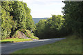
6
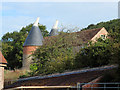
Oast House at Hope End Farm, Ridgeway Cross, Cradley
Image: © Oast House Archive
Taken: 28 Aug 2015
0.24 miles
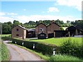
7
Oast House at Hope End Farm, Ridgeway Cross, Cradley
Image: © Oast House Archive
Taken: 28 Aug 2015
0.24 miles
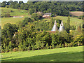
8
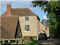
Oast House at Hope End Farm, Ridgeway Cross, Cradley
Image: © Oast House Archive
Taken: 28 Aug 2015
0.24 miles
9
Oast House at Hope End Farm, Ridgeway Cross, Cradley
Image: © Oast House Archive
Taken: 28 Aug 2015
0.24 miles