IMAGES TAKEN NEAR TO
Sandlin, MALVERN, WR13 5DN
Introduction
This page details the photographs taken nearby to Sandlin, WR13 5DN by members of the Geograph project.
The Geograph project started in 2005 with the aim of publishing, organising and preserving representative images for every square kilometre of Great Britain, Ireland and the Isle of Man.

There are currently over 7.5m images from over14,400 individuals and you can help contribute to the project by visiting https://www.geograph.org.uk
Image Map (6 Images)


Getting Data...Please wait
Leaflet Map data © OpenStreetMap
Images are licensed for reuse under creativecommons.org/licenses/by-sa/2.0
Notes
- Clicking on the map will re-center to the selected point.
- The higher the marker number, the further away the image location is from the centre of the postcode.
Image Listing (6 Images Found)
Images are licensed for reuse under creativecommons.org/licenses/by-sa/2.0
Image
Details
Distance
1
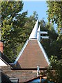
Hop Kiln Cottage, Smith End Green
Image: © Oast House Archive
Taken: 11 Sep 2014
0.02 miles
2
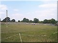
Paddocks at Sandlin Farm
Paddocks equipped with everything for show jumping.
Image: © Bob Embleton
Taken: 22 Sep 2005
0.09 miles
4
Field entrance
Field entrance near Lower Sandlin Farm at Smith End Green.
Image: © Philip Halling
Taken: 12 Jul 2013
0.11 miles
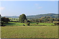
5
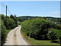
Coles Green Lane
Looking down toward the Sandlin farms.
Image: © Peter Whatley
Taken: 9 Jun 2008
0.21 miles
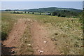
6
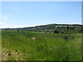
Fields off Coles Green Lane
Note that the OS 1:50k map is woefully inaccurate in this vicinity, though the 1:25k map is almost correct. A new house (September Cottage) is visible on the extreme correct of the photo.
Image: © Peter Whatley
Taken: 9 Jun 2008
0.25 miles