IMAGES TAKEN NEAR TO
Monksfield Lane, MALVERN, WR13 5BB
Introduction
This page details the photographs taken nearby to Monksfield Lane, WR13 5BB by members of the Geograph project.
The Geograph project started in 2005 with the aim of publishing, organising and preserving representative images for every square kilometre of Great Britain, Ireland and the Isle of Man.

There are currently over 7.5m images from over14,400 individuals and you can help contribute to the project by visiting https://www.geograph.org.uk
Image Map (Loading...)


Getting Data...Please wait
Leaflet Map data © OpenStreetMap
Images are licensed for reuse under creativecommons.org/licenses/by-sa/2.0
Notes
- Clicking on the map will re-center to the selected point.
- The higher the marker number, the further away the image location is from the centre of the postcode.
Image Listing (6 Images Found)
Images are licensed for reuse under creativecommons.org/licenses/by-sa/2.0
Image
Details
Distance
1

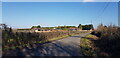
Concrete road
Leading east from the end of Monksfield Lane towards the Charles Faram Hop Store.
Image: © Jonathan Billinger
Taken: 20 Oct 2008
0.09 miles
2

Road to Lodge Farm
Monksfield Lane becomes a bridleway from this point on.
Image: © Jonathan Billinger
Taken: 20 Oct 2008
0.10 miles
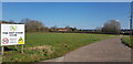
3
Looking along Monksfield Lane Towards Little Monksfield Farm
Image: © Paul Collins
Taken: 27 Feb 2022
0.18 miles
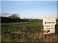
4
Lodge Farm, Newland
The Hop Store is a business of Charles Faram Ltd, hop factors. The sign has been replaced since 2005 Image
Image: © Paul Collins
Taken: 27 Feb 2022
0.19 miles
5
Lodge Farm
At the end of the public road at Monksfield. Looking north east towards Powick.
Image: © Bob Embleton
Taken: 9 Nov 2005
0.22 miles
6
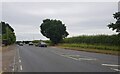
The A449, Worcester Road near Pins Green
Image: © Jeff Gogarty
Taken: 12 Jul 2022
0.24 miles