IMAGES TAKEN NEAR TO
Lowesmoor Place, WORCESTER, WR1 2PB
Introduction
This page details the photographs taken nearby to Lowesmoor Place, WR1 2PB by members of the Geograph project.
The Geograph project started in 2005 with the aim of publishing, organising and preserving representative images for every square kilometre of Great Britain, Ireland and the Isle of Man.

There are currently over 7.5m images from over14,400 individuals and you can help contribute to the project by visiting https://www.geograph.org.uk
Image Map (Loading...)


Getting Data...Please wait
Leaflet Map data © OpenStreetMap
Images are licensed for reuse under creativecommons.org/licenses/by-sa/2.0
Notes
- Clicking on the map will re-center to the selected point.
- The higher the marker number, the further away the image location is from the centre of the postcode.
Image Listing (635 Images Found)
Images are licensed for reuse under creativecommons.org/licenses/by-sa/2.0
Image
Details
Distance
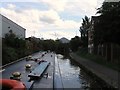
1
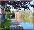
Towpath along the Worcester and Birmingham Canal
Looking towards Rainbow Hill Bridge No 9.
Image: © Mat Fascione
Taken: 19 Apr 2021
0.01 miles
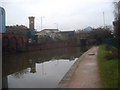
2
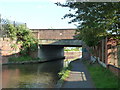
Worcester & Birmingham Canal - Bridge No. 8
Carrying the B4206 and known as Lowesmoor Bridge.
Image: © Chris Allen
Taken: 17 May 2014
0.01 miles
3
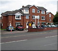
Lowesmoor House, Lowesmoor Place, Worcester
Managed by Nexus Housing, Lowesmoor House on the west bank of the Worcester & Birmingham Canal is retirement/sheltered housing built in 1991.
Image: © Jaggery
Taken: 29 Jul 2017
0.01 miles
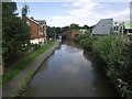
4
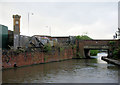
Clocktower and Lowesmoor Bridge
Worcester and Birmingham Canal, heading south.
Image: © Pierre Terre
Taken: 16 May 2009
0.01 miles
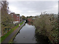
6
Worcester & Birmingham Canal at Lowesmoor
Looking south between the two road bridges.
Image: © Trevor Rickard
Taken: 28 Jan 2009
0.02 miles
8
Worcester and Birmingham Canal from Lowesmoor Place
Image: © Chris Allen
Taken: 24 Nov 2022
0.02 miles
9
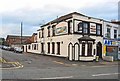
West Midland Tavern (1), Lowesmoor Place, Worcester
This old pub is on the corner of Lowesmoor Place and Padmore Street, within easy walking distance of Worcester Shrub Hill Railway Station. According to the useful website midlandspubs.co.uk, in the 19th century the pub was known as the West Midlands Arms, and may perhaps have been the beerhouse called the Sun listed in the 1851 census. This was some years before the railway station opened.
Image
Image: © P L Chadwick
Taken: 13 Jul 2012
0.03 miles
10
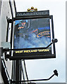
West Midland Tavern (2) - sign, Lowesmoor Place, Worcester
The sign reflects the fact that the pub is not far from Worcester Shrub Hill Railway Station, which between 1860 and 1863 was operated by the West Midland Railway. They amalgamated with the much larger Great Western Railway in August 1863.
The name of the well known brewers, Marston's, seems to have been partially obliterated. The pub is not listed on any of their websites, so presumably at some point they sold it off.
Image
Image: © P L Chadwick
Taken: 13 Jul 2012
0.03 miles