IMAGES TAKEN NEAR TO
Portland Street, WORCESTER, WR1 2NY
Introduction
This page details the photographs taken nearby to Portland Street, WR1 2NY by members of the Geograph project.
The Geograph project started in 2005 with the aim of publishing, organising and preserving representative images for every square kilometre of Great Britain, Ireland and the Isle of Man.

There are currently over 7.5m images from over14,400 individuals and you can help contribute to the project by visiting https://www.geograph.org.uk
Image Map (Loading...)


Getting Data...Please wait
Leaflet Map data © OpenStreetMap
Images are licensed for reuse under creativecommons.org/licenses/by-sa/2.0
Notes
- Clicking on the map will re-center to the selected point.
- The higher the marker number, the further away the image location is from the centre of the postcode.
Image Listing (1473 Images Found)
Images are licensed for reuse under creativecommons.org/licenses/by-sa/2.0
Image
Details
Distance
1
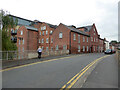
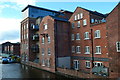
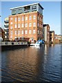
Former flour mill, Mill Street, Worcester
The bridge crosses the Worcester and Birmingham Canal. The mill has been converted to apartments.
Image: © Chris Allen
Taken: 1 Sep 2021
0.00 miles
2
Flats on converted flour mill
Diglis Basin, Worcester
Image: © Jeff Gogarty
Taken: 22 Aug 2010
0.01 miles
3
Former flour mill, Mill Street, Worcester
Alongside the Worcester and Birmingham Canal. Now converted to accommodation.
Image: © Chris Allen
Taken: 1 Sep 2021
0.01 miles
4
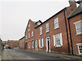
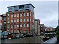
Former Albion flour mill, Mill Street, Worcester
Now converted to housing.
Image: © Stephen Craven
Taken: 7 Feb 2015
0.01 miles
5
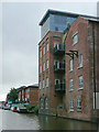
Apartments in former Albion Mill by the Worcester and Birmingham Canal
Image: © David Martin
Taken: 19 Nov 2016
0.01 miles
6
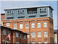
Worcester and Birmingham Canal at Diglis
Looking at new and restored buildings north-east of the basin, towards Mill Street Bridge, No 2.
The whole vicinity of the Worcester and Birmingham Canal from Sidbury Bridge (No 3) to Diglis Basin is being thoroughly regenerated with new apartment blocks, and others in converted old warehouses. I can't say I care much for the monstrosity stuck on top of this one. How on earth did that design pass the area architectural compatibility planning stage?
Image: © Roger D Kidd
Taken: 20 Aug 2010
0.01 miles
7
Converted warehouse near Diglis canal basin, Worcester
The whole vicinity of the Worcester and Birmingham Canal from Sidbury Bridge (No 3) to Diglis Basin is being thoroughly regenerated with new apartment blocks, and others in converted old warehouses. I can't say I care much for the monstrosity stuck on top of this one. How did its design pass the compatibility planning stage?
Image: © Roger D Kidd
Taken: 20 Aug 2010
0.01 miles
8
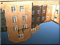
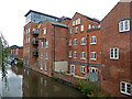
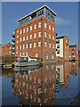
Reflections in the Worcester and Birmingham Canal
Former factory buildings which have been converted in residential accommodation reflected in the Worcester and Birmingham Canal near Diglis, Worcester.
Image: © Philip Halling
Taken: 16 Jan 2012
0.01 miles
9
Worcester - former flour mill
Now converted to apartments and alongside the Worcester & Birmingham canal on the approach to Diglis Basin.
Image: © Chris Allen
Taken: 9 Nov 2014
0.01 miles
10
Converted factories
Converted factories beside the Worcester and Birmingham Canal in Diglis Worcester.
Image: © Philip Halling
Taken: 22 Jan 2016
0.01 miles