IMAGES TAKEN NEAR TO
Stanton, BROADWAY, WR12 7ND
Introduction
This page details the photographs taken nearby to WR12 7ND by members of the Geograph project.
The Geograph project started in 2005 with the aim of publishing, organising and preserving representative images for every square kilometre of Great Britain, Ireland and the Isle of Man.

There are currently over 7.5m images from over14,400 individuals and you can help contribute to the project by visiting https://www.geograph.org.uk
Image Map (Loading...)


Getting Data...Please wait
Leaflet Map data © OpenStreetMap
Images are licensed for reuse under creativecommons.org/licenses/by-sa/2.0
Notes
- Clicking on the map will re-center to the selected point.
- The higher the marker number, the further away the image location is from the centre of the postcode.
Image Listing (16 Images Found)
Images are licensed for reuse under creativecommons.org/licenses/by-sa/2.0
Image
Details
Distance
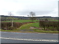
1
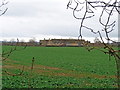
Stanton Fields
The property known as Stanton Fields is seen from the footpath.
Image: © Michael Dibb
Taken: 31 Dec 2011
0.03 miles
2
Gloucestershire Warkwickshire Railway
Heading north on the extension to Laverton
Image: © Gareth James
Taken: 23 May 2015
0.05 miles
3
![Stanton Fields [1]](https://s0.geograph.org.uk/geophotos/02/81/57/2815744_e8155bfa_120x120.jpg)
Stanton Fields [1]
From the small lay-by, created when the B4632 (formerly the A46) was realigned, a driveway runs to Stanton Fields, a grade II listed house and a collection of farm buildings. The parapet of the bridge over the relaid Gloucestershire Warwickshire Railway can be seen in the distance. Built in the early years of the twentieth century (1900-1906) the line from Cheltenham to Honeybourne closed to passengers in 1968 and to freight in 1976. The line is being re-opened as far as Honeybourne.
Image: © Michael Dibb
Taken: 31 Dec 2011
0.12 miles
4
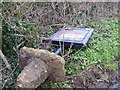
Data down
It is usually a computer that is 'down' but here it is the local information board, situated in a small lay-by alongside the B4632.
Image: © Michael Dibb
Taken: 31 Dec 2011
0.13 miles
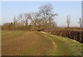
6
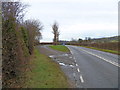
Straightened road
This small lay-by was created when the road, now the B4632 but formerly the very busy A46, was realigned and straightened.
Image: © Michael Dibb
Taken: 31 Dec 2011
0.15 miles
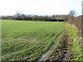
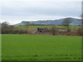
7
Bridleway meets road
The short bridleway from Stanton ends here where it meets the B4632 road (formerly the A46). The houses of Stanton can be seen in the distance with the Cotswold escarpment behind.
Image: © Michael Dibb
Taken: 31 Dec 2011
0.16 miles
9
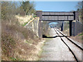
Overbridges, Gloucestershire Warwickshire Railway
The B4632 crosses the near bridge.
Image: © Robin Webster
Taken: 6 Apr 2015
0.16 miles
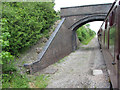
10
Road over railway
Seen from the bridleway the bridge carries the B4632 road (formerly the A46) over the relaid Gloucestershire Warwickshire Railway. Built in the early years of the twentieth century (1900-1906) the line from Cheltenham to Honeybourne closed to passengers in 1968 and to freight in 1976. The line is being re-opened as far as Honeybourne. Alderton Hill, a outlier from the Cotswold escarpment, is in the distance.
Image: © Michael Dibb
Taken: 31 Dec 2011
0.17 miles