IMAGES TAKEN NEAR TO
Buckland Fields, BROADWAY, WR12 7JQ
Introduction
This page details the photographs taken nearby to Buckland Fields, WR12 7JQ by members of the Geograph project.
The Geograph project started in 2005 with the aim of publishing, organising and preserving representative images for every square kilometre of Great Britain, Ireland and the Isle of Man.

There are currently over 7.5m images from over14,400 individuals and you can help contribute to the project by visiting https://www.geograph.org.uk
Image Map (Loading...)


Getting Data...Please wait
Leaflet Map data © OpenStreetMap
Images are licensed for reuse under creativecommons.org/licenses/by-sa/2.0
Notes
- Clicking on the map will re-center to the selected point.
- The higher the marker number, the further away the image location is from the centre of the postcode.
Image Listing (14 Images Found)
Images are licensed for reuse under creativecommons.org/licenses/by-sa/2.0
Image
Details
Distance
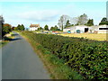
1
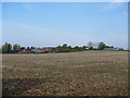
Farm & Fields
To the left of the image is the farm named Buckland Fields. To the right of the image is Mocho Farm. Seen from the footpath.
Image: © Michael Dibb
Taken: 1 Oct 2011
0.04 miles
2
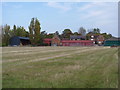
Buckland Fields
The farm known as Buckland Fields is seen from the footpath.
Image: © Michael Dibb
Taken: 1 Oct 2011
0.05 miles
3
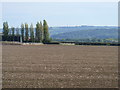
A view of the tower
From the footpath, a view to Broadway Tower atop the scarp slope. Buckland Fields Farm is to the left of the image.
Image: © Michael Dibb
Taken: 1 Oct 2011
0.08 miles
4
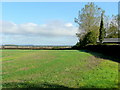
View to the Vale
Looking north along the line of a footpath from Buckland Fields past the rear of Mocho Farm.
Image: © Jonathan Billinger
Taken: 24 Sep 2009
0.08 miles
5
Mocho Farm
Looking west along the lane to Aston Somerville.
Image: © Jonathan Billinger
Taken: 24 Sep 2009
0.11 miles
6
Buckland Fields
Buckland Fields, looking south towards the Cotswolds from Mocho Farm
Image: © Dave Bushell
Taken: 5 Sep 2005
0.12 miles
7
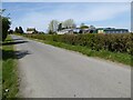
Mocho Farm
Mocho Farm beside Broadway Road near Aston Somerville.
Image: © Philip Halling
Taken: 26 Apr 2021
0.13 miles
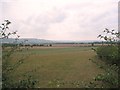
8

Bucklands Fields
Farmland to the east of Aston Somerville and just within the county of Gloucestershire. View to the south-west and Dumbleton Hill.
Image: © Philip Halling
Taken: 7 Mar 2009
0.14 miles
9

Towards the church
Having passed over the county boundary, the footpath runs straight across this field. The tower of the church of St Mary the Virgin at Aston Somerville is in the distance.
Image: © Michael Dibb
Taken: 1 Oct 2011
0.16 miles
10

Over the stile
Having run alongside the fence for some distance, the footpath now passes over the stile and runs across a corner of the field. The hedge at the far side of the field is the county boundary between Gloucestershire (this side) and Worcestershire.
Image: © Michael Dibb
Taken: 1 Oct 2011
0.17 miles