IMAGES TAKEN NEAR TO
Woodland Close, BROADWAY, WR12 7JL
Introduction
This page details the photographs taken nearby to Woodland Close, WR12 7JL by members of the Geograph project.
The Geograph project started in 2005 with the aim of publishing, organising and preserving representative images for every square kilometre of Great Britain, Ireland and the Isle of Man.

There are currently over 7.5m images from over14,400 individuals and you can help contribute to the project by visiting https://www.geograph.org.uk
Image Map (Loading...)


Getting Data...Please wait
Leaflet Map data © OpenStreetMap
Images are licensed for reuse under creativecommons.org/licenses/by-sa/2.0
Notes
- Clicking on the map will re-center to the selected point.
- The higher the marker number, the further away the image location is from the centre of the postcode.
Image Listing (68 Images Found)
Images are licensed for reuse under creativecommons.org/licenses/by-sa/2.0
Image
Details
Distance
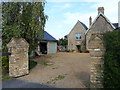
1
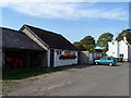
Aston Somerville Social Club
The club is located in Church Road.
Image: © Michael Dibb
Taken: 1 Oct 2011
0.08 miles
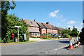
2
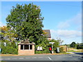
Bus shelter in the centre of Aston Somerville
Set at the only road junction in the village.
Left for Wormington, right for Hinton and Evesham.
Image: © Jonathan Billinger
Taken: 24 Sep 2009
0.09 miles
3
Footpath to Broadway Road
This short footpath runs from Church Road to Broadway Road.
Image: © Michael Dibb
Taken: 1 Oct 2011
0.09 miles
4
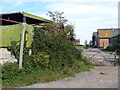
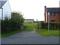
Farm in Aston Somerville
Farm beside the lane giving access to Aston Somerville church.
Image: © Philip Halling
Taken: 30 Jan 2011
0.09 miles
5
Path meets road
This short footpath links Church Road with Broadway Road.
Image: © Michael Dibb
Taken: 1 Oct 2011
0.10 miles
6
Footpath leaves the road
The footpath runs to Wormington.
Image: © Michael Dibb
Taken: 1 Oct 2011
0.10 miles
7
Road junction at Aston Somerville
The signs on the right announce that the road ahead is closed due to work on the railway bridge at Little Buckland.
Image: © Trevor Harris
Taken: 22 Jul 2014
0.10 miles
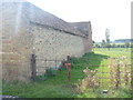
9
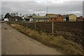
![Top Farm [2]](https://s1.geograph.org.uk/geophotos/02/75/17/2751741_2023a672_120x120.jpg)
Top Farm [2]
These buildings, part of Top Farm, have not yet been converted to residential use.
Image: © Michael Dibb
Taken: 1 Oct 2011
0.11 miles
10
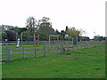
Play area
This children's play area has recently been established in Aston Somerville.
Image: © Michael Dibb
Taken: 1 Oct 2011
0.11 miles