IMAGES TAKEN NEAR TO
High Street, BROADWAY, WR12 7AJ
Introduction
This page details the photographs taken nearby to High Street, WR12 7AJ by members of the Geograph project.
The Geograph project started in 2005 with the aim of publishing, organising and preserving representative images for every square kilometre of Great Britain, Ireland and the Isle of Man.

There are currently over 7.5m images from over14,400 individuals and you can help contribute to the project by visiting https://www.geograph.org.uk
Image Map
Images are licensed for reuse under creativecommons.org/licenses/by-sa/2.0
Notes
- Clicking on the map will re-center to the selected point.
- The higher the marker number, the further away the image location is from the centre of the postcode.
Image Listing (261 Images Found)
Images are licensed for reuse under creativecommons.org/licenses/by-sa/2.0
Image
Details
Distance
1
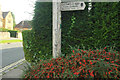
Cotswold Way at Broadway
The signpost points down Broadway footpath 607(B), which takes the Way towards Broadway Tower on top of the scarp. In the other direction, the Way follows the High Street behind the camera and through the centre of Broadway.
Image: © Derek Harper
Taken: 17 Sep 2021
0.02 miles
3
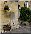
Grade II Listed milestone outside Milestone House, Broadway, Worcestershire
Late 18th century milestone on the right here. https://www.geograph.org.uk/photo/6350808 A plate on the stone records that the milestone was defaced
under defence regulations in 1939. It was restored by public subscription to commemorate the coronation of Her Majesty Queen Elizabeth II on June 2nd 1953.
Image: © Jaggery
Taken: 1 May 2016
0.02 miles
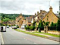
4
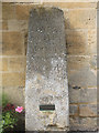
Old Milestone in High Street, Broadway
Carved stone post by the UC road (was A44), in parish of Broadway (Wychavon District), No. 122 High Street, by Milestone House, in pavement, back to wall, on North side of road. Evesham stone, erected by the Evesham Second District turnpike trust in the 19th century.
Inscription reads:-
To
LONDON
90 Miles
Moreton 8
STOW 10
WORCESTER
21
Evesham 6
{Inset metal plaque}
Grade II listed.
List Entry Number: 1288456 https://historicengland.org.uk/listing/the-list/list-entry/1288456
Milestone Society National ID: WO_LW90
Image: © J Higgins
Taken: 25 Sep 2008
0.02 miles
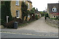
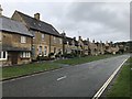
6
Peel House
Peel House was built as a Police House in the early 20th century. Pevsner isn't particularly complimentary about this house.
Image: © Philip Halling
Taken: 17 Mar 2019
0.02 miles
7
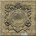
Worcestershire coat of arms
Worcestershire coat of arms on the former Police House in Broadway. 'Comitatus wigorniensis' is Latin for Worcestershire County.
Image: © Philip Halling
Taken: 17 Mar 2019
0.02 miles
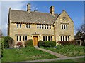
8
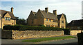
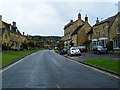
Houses, High Street, Broadway
Seen from where the Cotswold Way joins the road, turning left away from the house in the centre.
Image: © Derek Harper
Taken: 17 Sep 2021
0.02 miles