IMAGES TAKEN NEAR TO
Somerset Place, WORCESTER, WR1 1QL
Introduction
This page details the photographs taken nearby to Somerset Place, WR1 1QL by members of the Geograph project.
The Geograph project started in 2005 with the aim of publishing, organising and preserving representative images for every square kilometre of Great Britain, Ireland and the Isle of Man.

There are currently over 7.5m images from over14,400 individuals and you can help contribute to the project by visiting https://www.geograph.org.uk
Image Map
Images are licensed for reuse under creativecommons.org/licenses/by-sa/2.0
Notes
- Clicking on the map will re-center to the selected point.
- The higher the marker number, the further away the image location is from the centre of the postcode.
Image Listing (183 Images Found)
Images are licensed for reuse under creativecommons.org/licenses/by-sa/2.0
Image
Details
Distance
1

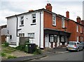
The Lansdowne Inn (1), 19-20 Lansdowne Street, Worcester
Another of Worcester's declining number of back street public houses. It is located on the corner of White Ladies Walk and Lansdowne Street. When photographed in October 2012 it was open, but sadly it closed sometime around the middle of 2013. In February 2014 a planning application to turn it into two houses and a groundfloor flat had been submitted to the planning authority.
This pub, as can be seen, was at one time a Hansons house. Julia Hanson & Sons Limited had its origins in a wine & spirit business which later went into brewing in Dudley. In 1943 the firm was taken over by Wolverhampton & Dudley Breweries Ltd but in the early 1990's the brewery closed and production was moved to Wolverhampton. There are not many pubs which still have Hansons signage and it looks as if there is now going to be one fewer.
Image
Image
The closed pub photographed in August 2017:- Image
Image: © P L Chadwick
Taken: 6 Oct 2012
0.05 miles
2

The Lansdowne Inn (2) - sign, 19-20 Lansdowne Street, Worcester
Looking distinctly home made, the sign is as basic as you can get. The public house takes its name from the street or maybe it was the other way around.
Image
Image
Image: © P L Chadwick
Taken: 6 Oct 2012
0.05 miles
3

The Lansdowne Inn (3), 19-20 Lansdowne Street, Worcester
A view of the front of the pub which unfortunately had to be taken into the sun, but the shot is probably unrepeatable as the pub has now closed.
Image
Image
Image: © P L Chadwick
Taken: 6 Oct 2012
0.05 miles
4
The former Lansdowne Inn, 19-20 Lansdowne Street, Worcester
Located on the corner of Lansdowne Street and White Ladies Walk, this former Julia Hanson public house closed a few years ago. All the signage has gone, although the bracket from which the pub sign hung still remains. The building is apparently now in residential use.
The pub when open in October 2012:- Image
Image: © P L Chadwick
Taken: 11 Aug 2017
0.05 miles
5
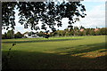
Houses on Flag Meadow Walk, Worcester
Houses on Flag Meadow Walk viewed from the canal across Flagge Meadow playing field which belows to Worcester Grammar School.
Image: © Philip Halling
Taken: 13 Feb 2010
0.05 miles
6
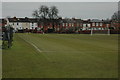
Flag Meadow, Worcester
Flag Meadow is the playing field for Worcester's Royal Grammar School. The pavilion replaced a smaller traditional one in the early 1990s. Behind the trees on the far side of the meadow is the Worcester to Birmingham canal. The meadow falls into four different grid squares.
Image: © Philip Halling
Taken: 21 Sep 2005
0.07 miles
7
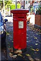
Queen Victoria postbox, Shrubbery Avenue, Worcester
The postbox has Queen Victoria's Royal Cipher (VR) and probably dates from the 1890's, when this area seems to have been developed. It is located near the corner of Shrubbery Avenue and Flag Meadow Walk. See:- Image
Postbox number:- WR1 121. Post code:- WR1 1QN. Last collection:- 6 p.m. Monday to Friday; 11.30 a.m. Saturday.
Image: © P L Chadwick
Taken: 6 Oct 2012
0.07 miles
8
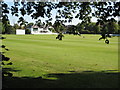
Flag Meadow playing field, Worcester
Royal Worcester Grammar School's playing field during the cricket season, the covers can be seen on the right.
Image: © Philip Halling
Taken: 1 Jul 2008
0.07 miles
9
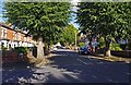
Flagmeadow Walk, Worcester
Flagmeadow Walk overlooks the Royal Worcester Grammar sports field named Flag Meadow.
Image: © Philip Halling
Taken: 1 Jul 2008
0.07 miles
10
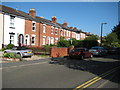
Shrubbery Avenue near its junction with Flag Meadow Walk, Worcester
A pleasant mainly Victorian residential road, much nearer the city centre than one might think. In the foreground is Flag Meadow Walk, which these days is a public road not a footpath. Just by the parked car, on the right, is a Victorian postbox, which can also be seen here:- Image
Image: © P L Chadwick
Taken: 6 Oct 2012
0.07 miles