IMAGES TAKEN NEAR TO
South Littleton, EVESHAM, WR11 8TS
Introduction
This page details the photographs taken nearby to WR11 8TS by members of the Geograph project.
The Geograph project started in 2005 with the aim of publishing, organising and preserving representative images for every square kilometre of Great Britain, Ireland and the Isle of Man.

There are currently over 7.5m images from over14,400 individuals and you can help contribute to the project by visiting https://www.geograph.org.uk
Image Map (Loading...)


Getting Data...Please wait
Leaflet Map data © OpenStreetMap
Images are licensed for reuse under creativecommons.org/licenses/by-sa/2.0
Notes
- Clicking on the map will re-center to the selected point.
- The higher the marker number, the further away the image location is from the centre of the postcode.
Image Listing (2 Images Found)
Images are licensed for reuse under creativecommons.org/licenses/by-sa/2.0
Image
Details
Distance
1
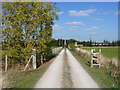
Footpaths cross
At this point, the footpath along the drive is crossed by a footpath from Shinehill Lane to Buckle Street via Sheen Hill. Buckle Street is on the line of the Roman Road Ryknild Street.
Image: © Michael Dibb
Taken: 15 Oct 2011
0.22 miles
2
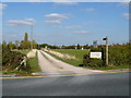
Cottage drive and footpath
Seen from Sheenhill Road, the driveway serving Holborn Cottage and Holborn Boarding Kennels is also a public footpath.
Image: © Michael Dibb
Taken: 15 Oct 2011
0.24 miles