IMAGES TAKEN NEAR TO
Pebworth Road, EVESHAM, WR11 8QL
Introduction
This page details the photographs taken nearby to Pebworth Road, WR11 8QL by members of the Geograph project.
The Geograph project started in 2005 with the aim of publishing, organising and preserving representative images for every square kilometre of Great Britain, Ireland and the Isle of Man.

There are currently over 7.5m images from over14,400 individuals and you can help contribute to the project by visiting https://www.geograph.org.uk
Image Map (Loading...)


Getting Data...Please wait
Leaflet Map data © OpenStreetMap
Images are licensed for reuse under creativecommons.org/licenses/by-sa/2.0
Notes
- Clicking on the map will re-center to the selected point.
- The higher the marker number, the further away the image location is from the centre of the postcode.
Image Listing (7 Images Found)
Images are licensed for reuse under creativecommons.org/licenses/by-sa/2.0
Image
Details
Distance
1
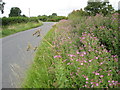
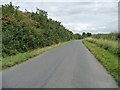
Roadside wildflowers, Littleton
Summer flowers are in bloom on the verge of this road from North Littleton to Pebworth.
Image: © Philip Halling
Taken: 24 Jul 2010
0.04 miles
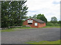
4
Littleton Football Club Pitch
A small stand has appeared since this football field was last photographed.Image]
Image: © Philip Halling
Taken: 24 Jul 2010
0.10 miles
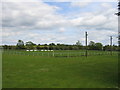
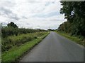
5
Blake's Hill [2]
Looking east towards Briarcroft.
Image: © Christine Johnstone
Taken: 20 Aug 2014
0.14 miles
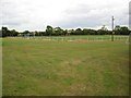
6
Blake's Hill [1]
Looking west towards the entrance to Blake House.
Image: © Christine Johnstone
Taken: 20 Aug 2014
0.16 miles
7
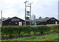
Dean's Farm
This is the Pebworth Poultry site and it obviously needs a fair amount of power to keep the chickes warm and fed, judging by the power line and transformers
Image: © Nigel Mykura
Taken: 9 Oct 2011
0.17 miles