IMAGES TAKEN NEAR TO
Nightingale Lane, EVESHAM, WR11 8LA
Introduction
This page details the photographs taken nearby to Nightingale Lane, WR11 8LA by members of the Geograph project.
The Geograph project started in 2005 with the aim of publishing, organising and preserving representative images for every square kilometre of Great Britain, Ireland and the Isle of Man.

There are currently over 7.5m images from over14,400 individuals and you can help contribute to the project by visiting https://www.geograph.org.uk
Image Map
Images are licensed for reuse under creativecommons.org/licenses/by-sa/2.0
Notes
- Clicking on the map will re-center to the selected point.
- The higher the marker number, the further away the image location is from the centre of the postcode.
Image Listing (6 Images Found)
Images are licensed for reuse under creativecommons.org/licenses/by-sa/2.0
Image
Details
Distance
2
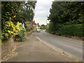
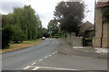
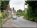
Cleeve Prior, B4085
The main road through the village.
Image: © David Dixon
Taken: 27 Jun 2017
0.10 miles
4
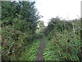
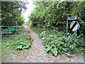
Avon River Walk
Out of sight of the river at the moment
Image: © Eirian Evans
Taken: 5 Aug 2017
0.23 miles
5
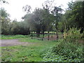
Path along Mill Lane, parallel to the Avon
Image: © Eirian Evans
Taken: 5 Aug 2017
0.23 miles