IMAGES TAKEN NEAR TO
Kingshurst Drive, EVESHAM, WR11 7ZF
Introduction
This page details the photographs taken nearby to Kingshurst Drive, WR11 7ZF by members of the Geograph project.
The Geograph project started in 2005 with the aim of publishing, organising and preserving representative images for every square kilometre of Great Britain, Ireland and the Isle of Man.

There are currently over 7.5m images from over14,400 individuals and you can help contribute to the project by visiting https://www.geograph.org.uk
Image Map (Loading...)


Getting Data...Please wait
Leaflet Map data © OpenStreetMap
Images are licensed for reuse under creativecommons.org/licenses/by-sa/2.0
Notes
- Clicking on the map will re-center to the selected point.
- The higher the marker number, the further away the image location is from the centre of the postcode.
Image Listing (5 Images Found)
Images are licensed for reuse under creativecommons.org/licenses/by-sa/2.0
Image
Details
Distance
1
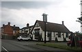
The Round of Gras pub, Badsey
I had to look up the meaning, it is a bundle of locally grown asparagus. https://www.badseysociety.uk/image/8378?gallery=48806
Image: © David Howard
Taken: 3 Aug 2019
0.14 miles
2
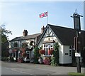
The Round of Gras
The Round of Gras at Badsey. Formerly the Royal Oak it was renamed in recognition of the annual asparagus auctions held at the pub.
Image: © Dave Bushell
Taken: 12 Sep 2005
0.14 miles
3
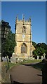
Badsey Church
Badsey Parish Church from the west.
Image: © Dave Bushell
Taken: 12 Sep 2005
0.14 miles
4
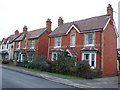
Weston Rd, Badsey
These attractive red brick victorian houses are on the west side of Badsey on the B4035 road just before Bretforton.
Image: © Nigel Mykura
Taken: 20 Feb 2011
0.16 miles
5
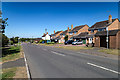
Birmingham Road, Badsey
The road heads north out of Badsey.
Image: © David P Howard
Taken: 12 Aug 2016
0.18 miles