IMAGES TAKEN NEAR TO
Chestnut Close, EVESHAM, WR11 7XW
Introduction
This page details the photographs taken nearby to Chestnut Close, WR11 7XW by members of the Geograph project.
The Geograph project started in 2005 with the aim of publishing, organising and preserving representative images for every square kilometre of Great Britain, Ireland and the Isle of Man.

There are currently over 7.5m images from over14,400 individuals and you can help contribute to the project by visiting https://www.geograph.org.uk
Image Map
Images are licensed for reuse under creativecommons.org/licenses/by-sa/2.0
Notes
- Clicking on the map will re-center to the selected point.
- The higher the marker number, the further away the image location is from the centre of the postcode.
Image Listing (4 Images Found)
Images are licensed for reuse under creativecommons.org/licenses/by-sa/2.0
Image
Details
Distance
2
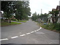
Aldington
Looking west up the main street in the small village of Aldington, an area of market gardening and horticulture.
Image: © Dave Bushell
Taken: 20 Sep 2005
0.06 miles
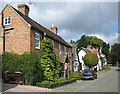
3

Old Bridge Marker on Horsebridge, Badsey Brook
Bridge Marker set in the parapet of Horsebridge, Badsey Brook, on the south side of the B4035 Badsey Road / Bretforton Road. On the boundary of Aldington and Badsey parishes.
Milestone Society National ID: WO_ALDBAD01br
Image: © Roadside Relics
Taken: 9 Sep 2024
0.24 miles
4
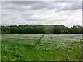
White-flowered linseed
Footpath through the crop, Aldington.
Image: © Liz Stone
Taken: 29 Jun 2013
0.24 miles