IMAGES TAKEN NEAR TO
Main Street, EVESHAM, WR11 7UH
Introduction
This page details the photographs taken nearby to Main Street, WR11 7UH by members of the Geograph project.
The Geograph project started in 2005 with the aim of publishing, organising and preserving representative images for every square kilometre of Great Britain, Ireland and the Isle of Man.

There are currently over 7.5m images from over14,400 individuals and you can help contribute to the project by visiting https://www.geograph.org.uk
Image Map (Loading...)


Getting Data...Please wait
Leaflet Map data © OpenStreetMap
Images are licensed for reuse under creativecommons.org/licenses/by-sa/2.0
Notes
- Clicking on the map will re-center to the selected point.
- The higher the marker number, the further away the image location is from the centre of the postcode.
Image Listing (19 Images Found)
Images are licensed for reuse under creativecommons.org/licenses/by-sa/2.0
Image
Details
Distance
1
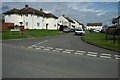
Churchill Road, Sedgeberrow
Post-war houses in the village of Sedgeberrow.
Image: © Philip Halling
Taken: 28 Mar 2010
0.05 miles
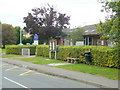
2
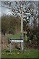
Signpost to Sedgeberrow
Signpost on Main Street in Sedgeberrow. This road is off the former A435 which was bypassed by the rerouted A46 some years ago.
Image: © Philip Halling
Taken: 28 Mar 2010
0.06 miles
3
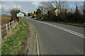
Former A435, Sedgeberrow
The former A435 entering the village of Sedgeberrow.
Image: © Philip Halling
Taken: 28 Mar 2010
0.08 miles
4
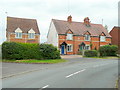
Architectural mimicry in Sedgeberrow
The new house on the left is styled after the farm/nursery workers' cottages which are dated 1909.
Image: © Jonathan Billinger
Taken: 15 Sep 2009
0.09 miles
5
Redundant nursery in Sedgeberrow
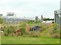
Situated at the west end of Main Street, viewed from the public footpath to Carrant Brook Farm and the A46.
Image: © Jonathan Billinger
Taken: 15 Sep 2009
0.12 miles
6
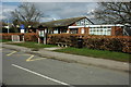
Sedgeberrow CE First School
Village primary school viewed from across Main Street.
Image: © Jonathan Billinger
Taken: 15 Sep 2009
0.14 miles
7
The old A435, Sedgeberrow
Until Sedgeberrow was bypassed this used to be the A435, pictured here is its junction with the A46.
Image: © Philip Halling
Taken: 7 Mar 2009
0.14 miles
8
Sedgeberrow School
Sedgeberrow CE First School.
Image: © Philip Halling
Taken: 28 Mar 2010
0.14 miles
9
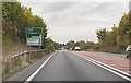
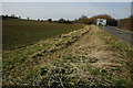
A46 near Sedgeberrow
Another junction with the B4078 to Sedgeberrow ahead.
Image: © J.Hannan-Briggs
Taken: 13 Oct 2016
0.14 miles
10
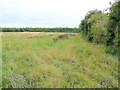
Footpath over rough pasture
Land to the west of the nursery in Image
Image: © Jonathan Billinger
Taken: 15 Sep 2009
0.15 miles