IMAGES TAKEN NEAR TO
Willow Close, EVESHAM, WR11 7SY
Introduction
This page details the photographs taken nearby to Willow Close, WR11 7SY by members of the Geograph project.
The Geograph project started in 2005 with the aim of publishing, organising and preserving representative images for every square kilometre of Great Britain, Ireland and the Isle of Man.

There are currently over 7.5m images from over14,400 individuals and you can help contribute to the project by visiting https://www.geograph.org.uk
Image Map (Loading...)


Getting Data...Please wait
Leaflet Map data © OpenStreetMap
Images are licensed for reuse under creativecommons.org/licenses/by-sa/2.0
Notes
- Clicking on the map will re-center to the selected point.
- The higher the marker number, the further away the image location is from the centre of the postcode.
Image Listing (15 Images Found)
Images are licensed for reuse under creativecommons.org/licenses/by-sa/2.0
Image
Details
Distance
1
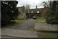
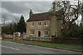
Old Manor Farm, Ashton under Hill
Farmhouse to Old Manor Farm in Ashton under Hill.
Image: © Philip Halling
Taken: 28 Mar 2010
0.12 miles
2
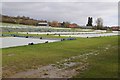
Polythene sheeting on a field below Bredon Hill
Polythene sheeting on a field near Ashton under Hill. Not sure why other than warming to soil to encourage earlier growth.
Image: © Philip Halling
Taken: 7 Feb 2016
0.12 miles
3
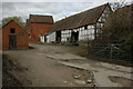
Old Manor Farm, Ashton under Hill
Traditional farm buildings at Old Manor Farm in Ashton under Hill.
Image: © Philip Halling
Taken: 28 Mar 2010
0.12 miles
4
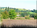
Ashton under Hill
The view north-west from by the dismantled railway line over the village to the south-east slope of Bredon Hill.
A crop of mature field beans in the foreground.
Image: © Jonathan Billinger
Taken: 11 Sep 2009
0.12 miles
5

Middle Farmhouse, Ashton under Hill
A later frontage to a seventeenth century house (visible on the left) https://historicengland.org.uk/listing/the-list/list-entry/1081665?section=official-list-entry
Image: © Jonathan Thacker
Taken: 5 Oct 2022
0.21 miles
6
House in Ashton under Hill
Cotswold stone built house in Ashton under Hill.
Image: © Philip Halling
Taken: 28 Mar 2010
0.22 miles
7
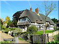
Chocolate Box cottage, Ashton under Hill
At least it maybe ought to be called that. The tower of St. Barbara's church can be seen far left in this sunny September-morn shot.
Jigsaw puzzle, anyone?
Image: © Jonathan Billinger
Taken: 11 Sep 2009
0.22 miles
9
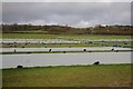
Polythene sheeting on a field
Polythene sheeting on a field near Ashton under Hill. Not sure why other than warming to soil to encourage earlier growth. Looking insignificant from this viewpoint the rising ground in the background is Bredon Hill which rises gently from the south-east before falling away sharply to the north-west.
Image: © Philip Halling
Taken: 7 Feb 2016
0.24 miles
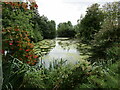
10
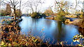
Ice laden pond
Given on mapping as a reservoir; this feature is nevertheless very decorative.
Image: © Jonathan Billinger
Taken: 29 Dec 2014
0.24 miles