IMAGES TAKEN NEAR TO
Washington Road, EVESHAM, WR11 7RY
Introduction
This page details the photographs taken nearby to Washington Road, WR11 7RY by members of the Geograph project.
The Geograph project started in 2005 with the aim of publishing, organising and preserving representative images for every square kilometre of Great Britain, Ireland and the Isle of Man.

There are currently over 7.5m images from over14,400 individuals and you can help contribute to the project by visiting https://www.geograph.org.uk
Image Map (Loading...)


Getting Data...Please wait
Leaflet Map data © OpenStreetMap
Images are licensed for reuse under creativecommons.org/licenses/by-sa/2.0
Notes
- Clicking on the map will re-center to the selected point.
- The higher the marker number, the further away the image location is from the centre of the postcode.
Image Listing (16 Images Found)
Images are licensed for reuse under creativecommons.org/licenses/by-sa/2.0
Image
Details
Distance
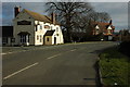
2
The Sandys Arms
Named after a local landed family dating from Elizabethan times this village pub used to be on the main road that ran through the village but a short section was bypassed and the traffic is now much quieter.
Image: © Nigel Mykura
Taken: 10 Jun 2011
0.12 miles
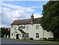
3
Sandys Arms, Wickhamford
This pub and part of the village is situated on what is now a bypassed loop off the main Evesham - Oxford road.
Image: © David Stowell
Taken: 17 Jun 2006
0.13 miles
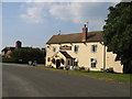
4
The former Sandys Arms
Another former public house, this one was the Sandys Arms as pictured here back in January 2011 Image], today a printed A4 sheet of paper reads 'James the Fish'.
Image: © Philip Halling
Taken: 1 Sep 2016
0.13 miles
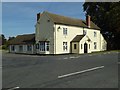
5
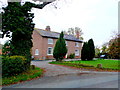
House at Wickham Farm
This is the main house for what appears to be a large working farm on the west side of Manor Road, the main road down through Wickhamford.
Image: © Nigel Mykura
Taken: 20 Nov 2011
0.16 miles
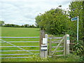
7
Start of bridleway
From the busy A44 road, this bridleway leads to Murcot Road.
Image: © Michael Dibb
Taken: 30 Jun 2010
0.20 miles
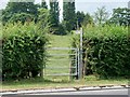
8
Footpath to Wickhamford church
Heading north from the Evesham Road.
Image: © Jonathan Billinger
Taken: 23 Jun 2011
0.21 miles
9
Houses In Sandys Avenue
This small terrace of houses is situated at the north end of this residential cul-de-sac. The houses back onto the local recreation and football ground.
Image: © Nigel Mykura
Taken: 10 Jun 2011
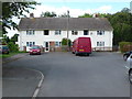
0.21 miles
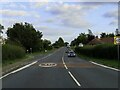
10
Ingenious ford
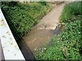
The busy A44 road is carried over Badsey Brook on a bridge. A concrete farm track also utilizes the bridge, fording the brook at the same time.
Image: © Michael Dibb
Taken: 30 Jun 2010
0.21 miles