IMAGES TAKEN NEAR TO
Cheltenham Road, EVESHAM, WR11 7QP
Introduction
This page details the photographs taken nearby to Cheltenham Road, WR11 7QP by members of the Geograph project.
The Geograph project started in 2005 with the aim of publishing, organising and preserving representative images for every square kilometre of Great Britain, Ireland and the Isle of Man.

There are currently over 7.5m images from over14,400 individuals and you can help contribute to the project by visiting https://www.geograph.org.uk
Image Map
Images are licensed for reuse under creativecommons.org/licenses/by-sa/2.0
Notes
- Clicking on the map will re-center to the selected point.
- The higher the marker number, the further away the image location is from the centre of the postcode.
Image Listing (8 Images Found)
Images are licensed for reuse under creativecommons.org/licenses/by-sa/2.0
Image
Details
Distance
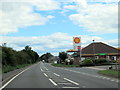
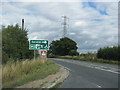
1
Services on the A46
Looking north-east at the Ashton services between Evesham and the Teddington Hands roundabout.
Image: © Jonathan Billinger
Taken: 18 Sep 2009
0.13 miles
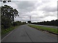
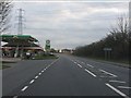
2
Pylons by the A46 near a service area
Image: © Sarah Charlesworth
Taken: 5 Aug 2010
0.14 miles
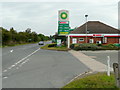
4
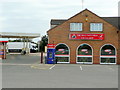
The Vale Cafeteria
A Truck Stop adjacent to the A46 at Ashton between Evesham and Teddington Hands.
Image: © Jonathan Billinger
Taken: 18 Sep 2009
0.15 miles
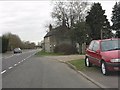
5
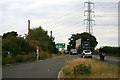
Lay-by on the A46
Dominated by a National Grid pylon in the next square.
Image: © David Lally
Taken: 27 Jul 2011
0.15 miles