IMAGES TAKEN NEAR TO
Pear Tree Lane, EVESHAM, WR11 7JT
Introduction
This page details the photographs taken nearby to Pear Tree Lane, WR11 7JT by members of the Geograph project.
The Geograph project started in 2005 with the aim of publishing, organising and preserving representative images for every square kilometre of Great Britain, Ireland and the Isle of Man.

There are currently over 7.5m images from over14,400 individuals and you can help contribute to the project by visiting https://www.geograph.org.uk
Image Map (Loading...)


Getting Data...Please wait
Leaflet Map data © OpenStreetMap
Images are licensed for reuse under creativecommons.org/licenses/by-sa/2.0
Notes
- Clicking on the map will re-center to the selected point.
- The higher the marker number, the further away the image location is from the centre of the postcode.
Image Listing (7 Images Found)
Images are licensed for reuse under creativecommons.org/licenses/by-sa/2.0
Image
Details
Distance
1
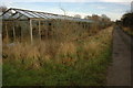
Old greenhouses near Badsey
Old greenhouses becoming overgrown with vegetation near Badsey.
Image: © Philip Halling
Taken: 28 Dec 2009
0.06 miles
2
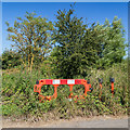
Road works barrier by the bridleway
This road works barrier looks like it has been beside the bridleway for some time, and is not going anywhere soon.
Image: © David P Howard
Taken: 12 Aug 2016
0.06 miles
3
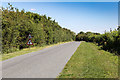
Pear Tree Corner
Willersey Road approaches Pear Tree Corner.
Image: © David P Howard
Taken: 12 Aug 2016
0.08 miles
4
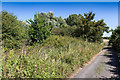
Bridleway towards Bretforton
Gravel track that is also a bridleway.
Image: © David P Howard
Taken: 12 Aug 2016
0.09 miles
5
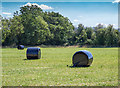
Silage bales in a field
Field south of the bridleway towards Bretforton.
Image: © David P Howard
Taken: 12 Aug 2016
0.09 miles
6
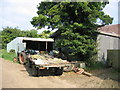
Tithe Barn
The OS Map shows a Tithe Barn at the end of this dead-end road from Pear Tree Corner. The barn itself, the tiled roof of which is just visible on the right, is however largely obscured by an ad-hoc collection of rather more modern extensions.
Image: © David Stowell
Taken: 17 Jun 2006
0.13 miles
7
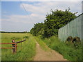
Bridleway
Looking ENE along the bridleway past the Tithe Barn near Pear Tree corner. From close inspection of the map it appears that this bridleway and part of Willersey road formed part of what was once a thoroughfare between Wickhamford and Honeybourne.
Image: © David Stowell
Taken: 17 Jun 2006
0.13 miles