IMAGES TAKEN NEAR TO
Atch Lench Road, EVESHAM, WR11 4UG
Introduction
This page details the photographs taken nearby to Atch Lench Road, WR11 4UG by members of the Geograph project.
The Geograph project started in 2005 with the aim of publishing, organising and preserving representative images for every square kilometre of Great Britain, Ireland and the Isle of Man.

There are currently over 7.5m images from over14,400 individuals and you can help contribute to the project by visiting https://www.geograph.org.uk
Image Map (Loading...)


Getting Data...Please wait
Leaflet Map data © OpenStreetMap
Images are licensed for reuse under creativecommons.org/licenses/by-sa/2.0
Notes
- Clicking on the map will re-center to the selected point.
- The higher the marker number, the further away the image location is from the centre of the postcode.
Image Listing (15 Images Found)
Images are licensed for reuse under creativecommons.org/licenses/by-sa/2.0
Image
Details
Distance
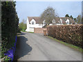
1

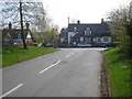
Main road junction at Church Lench - 2
View east down Atch Lench Road.
Image: © Trevor Rickard
Taken: 22 Apr 2008
0.09 miles
2
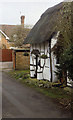
Toy Cottage, Church Lench
Literally a one up, one down abode - it apparently once accommodated 14 people.
Image: © Chris Heaton
Taken: 9 Feb 2003
0.11 miles
3
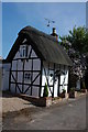
Toy Cottage, Church Lench
An attractive 'compact and bijou' thatched cottage in the village of Church Lench.
Image: © Philip Halling
Taken: 5 May 2007
0.12 miles
4
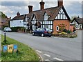
Main road junction at Church Lench - 1
Looking southwards to some attractive housing at the village centre.
Image: © Trevor Rickard
Taken: 22 Apr 2008
0.13 miles
5
Clover Cottage, Church Lench, Worcestershire
Village cottage in Church Lench, Worcestershire. An Ordnance Survey bench mark is located on the south facing wall.
Image
Image: © V1ncenze
Taken: 30 Apr 2021
0.13 miles
6

Ordnance Survey Bench Mark
This bench mark is located on a cottage in Church Lench, Worcestershire. These marks were used by Ordnance Survey for mapping purposes.
Image
Image: © V1ncenze
Taken: 30 Apr 2021
0.13 miles
7
Short lane at the south edge of Church Lench
Looking northwards from the edge of the village.
Image: © Trevor Rickard
Taken: 22 Apr 2008
0.14 miles
8

Wychavon Way approaching Church Lench
Looking northwards along the track to the outskirts of the village. The 42-mile Wychavon Way links Holt Fleet (north of Worcester on the Severn) to the Cotswolds, passing through many pretty Vale of Evesham villages like this one, and finally linking to the Cotswold Way at Winchcombe. This gentle walking route was originally opened in 1977 to commemorate the Silver Jubilee of Elizabeth II.
Image: © Trevor Rickard
Taken: 22 Apr 2008
0.14 miles
9
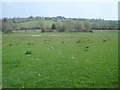
Paddocks at Church Lench
View south-east to Atch Lench on the hill opposite.
Image: © Trevor Rickard
Taken: 22 Apr 2008
0.15 miles
10
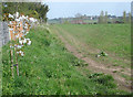
Footpath to Atch Lench
View eastwards from the footpath junction on the edge of Church Lench village. Atch Lench on the hill to the right. Nice to see at least a few young plum trees being planted.
Image: © Trevor Rickard
Taken: 22 Apr 2008
0.18 miles