IMAGES TAKEN NEAR TO
Hipton Hill, EVESHAM, WR11 4UA
Introduction
This page details the photographs taken nearby to Hipton Hill, WR11 4UA by members of the Geograph project.
The Geograph project started in 2005 with the aim of publishing, organising and preserving representative images for every square kilometre of Great Britain, Ireland and the Isle of Man.

There are currently over 7.5m images from over14,400 individuals and you can help contribute to the project by visiting https://www.geograph.org.uk
Image Map (Loading...)


Getting Data...Please wait
Leaflet Map data © OpenStreetMap
Images are licensed for reuse under creativecommons.org/licenses/by-sa/2.0
Notes
- Clicking on the map will re-center to the selected point.
- The higher the marker number, the further away the image location is from the centre of the postcode.
Image Listing (7 Images Found)
Images are licensed for reuse under creativecommons.org/licenses/by-sa/2.0
Image
Details
Distance
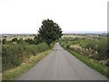
1
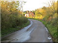
Road from Lenchwick to Church Lench
Looking north-westward towards Hipton Hill.
Image: © Peter Wood
Taken: 8 Nov 2017
0.06 miles
2
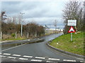
Travellers' site at Hipton Hill
Complete with CCTV surveillance.
Image: © Jonathan Billinger
Taken: 26 Feb 2010
0.07 miles
3
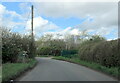
Hipton Road Lenchwick near the caravan park
Image: © Roy Hughes
Taken: 30 Mar 2024
0.07 miles

5

Hipton Hill Orchards
Older fruit trees on the south-east facing slope of the hill.
Image: © Jonathan Billinger
Taken: 26 Feb 2010
0.19 miles
6
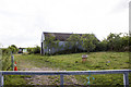
Hipton Hill Orchard
Modern farm building adjacent to Hipton Hill Orchard
Image: © P Gaskell
Taken: Unknown
0.20 miles
7
Hipton Hill
Hipton Hill looking east. A well-disguised council gypsy site in the middle distance.
Image: © Dave Bushell
Taken: 6 Sep 2005
0.24 miles