IMAGES TAKEN NEAR TO
Evesham Road, EVESHAM, WR11 4TW
Introduction
This page details the photographs taken nearby to Evesham Road, WR11 4TW by members of the Geograph project.
The Geograph project started in 2005 with the aim of publishing, organising and preserving representative images for every square kilometre of Great Britain, Ireland and the Isle of Man.

There are currently over 7.5m images from over14,400 individuals and you can help contribute to the project by visiting https://www.geograph.org.uk
Image Map
Images are licensed for reuse under creativecommons.org/licenses/by-sa/2.0
Notes
- Clicking on the map will re-center to the selected point.
- The higher the marker number, the further away the image location is from the centre of the postcode.
Image Listing (7 Images Found)
Images are licensed for reuse under creativecommons.org/licenses/by-sa/2.0
Image
Details
Distance
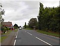
2
Junction of King's Lane and Evesham Road
Image: © Basher Eyre
Taken: 7 Mar 2016
0.14 miles
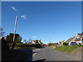
3
Norton : Kings Lane
Kings Lane in Norton taken from the road junction with St Egwin's Close.
Image: © Lewis Clarke
Taken: 21 Nov 2010
0.14 miles


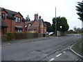
6

Houses at Norton
Houses on the B4088 at Norton to the north of Evesham.
Image: © Philip Halling
Taken: 22 Aug 2010
0.23 miles
7
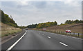
A46 near Norton
The road is in a cutting here.
Image: © J.Hannan-Briggs
Taken: 13 Oct 2016
0.25 miles