IMAGES TAKEN NEAR TO
Lenchwick, EVESHAM, WR11 4TG
Introduction
This page details the photographs taken nearby to WR11 4TG by members of the Geograph project.
The Geograph project started in 2005 with the aim of publishing, organising and preserving representative images for every square kilometre of Great Britain, Ireland and the Isle of Man.

There are currently over 7.5m images from over14,400 individuals and you can help contribute to the project by visiting https://www.geograph.org.uk
Image Map (Loading...)


Getting Data...Please wait
Leaflet Map data © OpenStreetMap
Images are licensed for reuse under creativecommons.org/licenses/by-sa/2.0
Notes
- Clicking on the map will re-center to the selected point.
- The higher the marker number, the further away the image location is from the centre of the postcode.
Image Listing (10 Images Found)
Images are licensed for reuse under creativecommons.org/licenses/by-sa/2.0
Image
Details
Distance
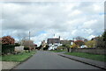
2
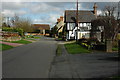
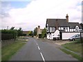
Lenchwick
The Vale of Evesham village of Lenchwick.
Image: © Philip Halling
Taken: 4 Apr 2010
0.12 miles
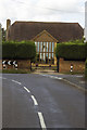
3
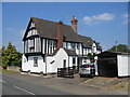
Lenchwick
One of the well cared for half-timbered buildings in this pleasant little village.
Image: © David Stowell
Taken: 17 Jun 2006
0.13 miles
5
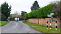
Fingerpost at Lenchwick
Three-way junction in the centre of this hamlet.
Image: © Jonathan Billinger
Taken: 3 Jan 2013
0.17 miles
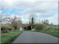
6

Junction of roads in Lenchwick
Looking north-westward.
Image: © Peter Wood
Taken: 8 Nov 2017
0.17 miles
8
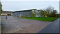
Manor Farm, Lenchwick
A large farm on the edge of this hamlet to the north-west of Evesham.
Image: © Jonathan Billinger
Taken: 3 Jan 2013
0.19 miles
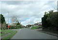
9
Lenchwick
Lenchwick village looking north-west
Image: © Dave Bushell
Taken: 6 Sep 2005
0.20 miles