IMAGES TAKEN NEAR TO
St. Philips Drive, EVESHAM, WR11 2RH
Introduction
This page details the photographs taken nearby to St. Philips Drive, WR11 2RH by members of the Geograph project.
The Geograph project started in 2005 with the aim of publishing, organising and preserving representative images for every square kilometre of Great Britain, Ireland and the Isle of Man.

There are currently over 7.5m images from over14,400 individuals and you can help contribute to the project by visiting https://www.geograph.org.uk
Image Map (Loading...)


Getting Data...Please wait
Leaflet Map data © OpenStreetMap
Images are licensed for reuse under creativecommons.org/licenses/by-sa/2.0
Notes
- Clicking on the map will re-center to the selected point.
- The higher the marker number, the further away the image location is from the centre of the postcode.
Image Listing (17 Images Found)
Images are licensed for reuse under creativecommons.org/licenses/by-sa/2.0
Image
Details
Distance
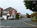
1
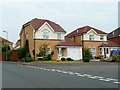
The Heathers, Evesham
Modern housing to the south of the town and north of the by-pass.
Image: © Jonathan Billinger
Taken: 18 Sep 2009
0.07 miles
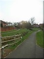
4
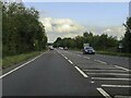
The A46 Evesham bypass
The A46 Evesham bypass on the southern side of the town, viewed here from a layby.
Image: © Philip Halling
Taken: 30 Jan 2011
0.10 miles

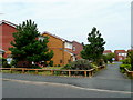
6
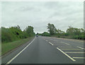
Celandine Way, Evesham
Modern housing to the south of the town and north of the by-pass.
Image: © Jonathan Billinger
Taken: 18 Sep 2009
0.14 miles
7
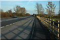
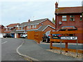
Jasmine Walk, Evesham
Modern housing to the south of the town and north of the by-pass.
Image: © Jonathan Billinger
Taken: 18 Sep 2009
0.15 miles
8
Lavender Walk, Evesham
Modern housing to the south of the town and north of the by-pass.
Image: © Jonathan Billinger
Taken: 18 Sep 2009
0.18 miles
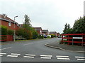
10
Larkspur Drive, Evesham
Modern housing to the south of the town and north of the by-pass.
Image: © Jonathan Billinger
Taken: 18 Sep 2009
0.20 miles