IMAGES TAKEN NEAR TO
Red Lane, EVESHAM, WR11 2RF
Introduction
This page details the photographs taken nearby to Red Lane, WR11 2RF by members of the Geograph project.
The Geograph project started in 2005 with the aim of publishing, organising and preserving representative images for every square kilometre of Great Britain, Ireland and the Isle of Man.

There are currently over 7.5m images from over14,400 individuals and you can help contribute to the project by visiting https://www.geograph.org.uk
Image Map (Loading...)


Getting Data...Please wait
Leaflet Map data © OpenStreetMap
Images are licensed for reuse under creativecommons.org/licenses/by-sa/2.0
Notes
- Clicking on the map will re-center to the selected point.
- The higher the marker number, the further away the image location is from the centre of the postcode.
Image Listing (6 Images Found)
Images are licensed for reuse under creativecommons.org/licenses/by-sa/2.0
Image
Details
Distance
1
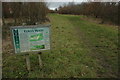
Eoves Wood
Eoves Wood is a Woodland Trust site and was purchased in 1997 through the 'Woods on your Doorstep' millennium project.
Image: © Philip Halling
Taken: 16 Jan 2011
0.11 miles
2
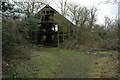
Old shed, Clark's Hill
The old ramshackle shed is beside a footpath on Clark's Hill just outside Evesham.
Image: © Philip Halling
Taken: 16 Jan 2011
0.13 miles
3
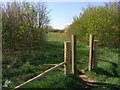
Entry to Eoves Wood from the track
An area of woodland and meadow created by the Woodland Trust after donations from the public. Area is access land with three access points.
Image: © Liz Stone
Taken: 15 Apr 2012
0.14 miles
4
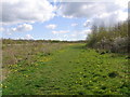
Permissive path in Eoves Wood along the edge of the meadow
Image: © Liz Stone
Taken: 15 Apr 2012
0.15 miles
5
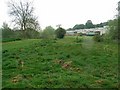
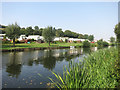
Hampton Ferry Caravan Park
On the bank of the River Avon.
Image: © David Luther Thomas
Taken: 23 Apr 2007
0.24 miles