IMAGES TAKEN NEAR TO
Boston Lane, EVESHAM, WR11 2RD
Introduction
This page details the photographs taken nearby to Boston Lane, WR11 2RD by members of the Geograph project.
The Geograph project started in 2005 with the aim of publishing, organising and preserving representative images for every square kilometre of Great Britain, Ireland and the Isle of Man.

There are currently over 7.5m images from over14,400 individuals and you can help contribute to the project by visiting https://www.geograph.org.uk
Image Map (Loading...)


Getting Data...Please wait
Leaflet Map data © OpenStreetMap
Images are licensed for reuse under creativecommons.org/licenses/by-sa/2.0
Notes
- Clicking on the map will re-center to the selected point.
- The higher the marker number, the further away the image location is from the centre of the postcode.
Image Listing (7 Images Found)
Images are licensed for reuse under creativecommons.org/licenses/by-sa/2.0
Image
Details
Distance
1
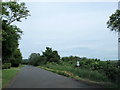
Footpath Sign Off Boston Lane Near Charlton
Image: © Roy Hughes
Taken: 1 Jun 2019
0.10 miles
2
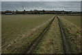
Farmland at Charlton
A footpath follows this track en route to Hampton and Evesham.
Image: © Philip Halling
Taken: 16 Jan 2011
0.15 miles
3
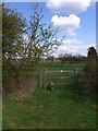
One after the other, stiles between paddocks
Path runs parallel to Boston Lane, between Boston Farm and Yessell Farm.
Image: © Liz Stone
Taken: 15 Apr 2012
0.19 miles
4
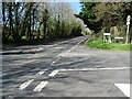
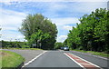
The Charlton turning
The Charlton turning off the B4084 to the west of Evesham.
Image: © Philip Halling
Taken: 4 Apr 2021
0.23 miles
5
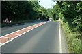
The B4084 west of Evesham
Roadworks to the west of Evesham.
Image: © Philip Halling
Taken: 3 Jul 2010
0.23 miles
6
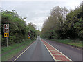
B4084 approaches junction with Boston Lane
Image: © Stuart Logan
Taken: 12 May 2013
0.23 miles