IMAGES TAKEN NEAR TO
Hinton-on-the-Green, EVESHAM, WR11 2QL
Introduction
This page details the photographs taken nearby to WR11 2QL by members of the Geograph project.
The Geograph project started in 2005 with the aim of publishing, organising and preserving representative images for every square kilometre of Great Britain, Ireland and the Isle of Man.

There are currently over 7.5m images from over14,400 individuals and you can help contribute to the project by visiting https://www.geograph.org.uk
Image Map (Loading...)


Getting Data...Please wait
Leaflet Map data © OpenStreetMap
Images are licensed for reuse under creativecommons.org/licenses/by-sa/2.0
Notes
- Clicking on the map will re-center to the selected point.
- The higher the marker number, the further away the image location is from the centre of the postcode.
Image Listing (7 Images Found)
Images are licensed for reuse under creativecommons.org/licenses/by-sa/2.0
Image
Details
Distance
1
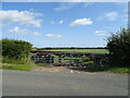
Blocked field entrance off National Cycle Route 41
Blocked by an old trailer.
Image: © JThomas
Taken: 12 Aug 2021
0.10 miles
2
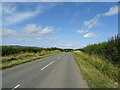
National Cycle Route 41
Towards Elmley Castle.
Image: © JThomas
Taken: 12 Aug 2021
0.11 miles
3
Site of Hinton Station
This was the site of Hinton Station before the Ashchurch to Evesham closed, today a trading estate occupies the site.
Image: © Philip Halling
Taken: 7 Mar 2009
0.15 miles
4
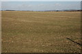
Farmland at Hinton on the Green
View to the north-west across farmland to the hills beyond the River Avon in the Lenches.
Image: © Philip Halling
Taken: 7 Mar 2009
0.16 miles
5
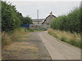
Hinton railway station (site), Worcestershire
Opened in 1864 by the Midland Railway on the "Gloucester Loop" line from Evesham to Gloucester, this station closed in 1963.
View along the approach road towards the forecourt. The railway ran left to right behind the building.
Image: © Nigel Thompson
Taken: 27 Jul 2013
0.19 miles
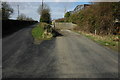
6
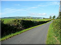
Station Road, Hinton on the Green
Looking west from the old railway bridge towards Ballard's Farm and Bredon Hill.
Image: © Jonathan Billinger
Taken: 9 Sep 2009
0.22 miles
7
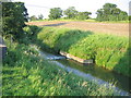
Gauging weir in the River Isbourne
Just south of Downrip Farm.
Image: © David Stowell
Taken: 17 Jun 2006
0.24 miles