IMAGES TAKEN NEAR TO
Orleans Close, EVESHAM, WR11 2FP
Introduction
This page details the photographs taken nearby to Orleans Close, WR11 2FP by members of the Geograph project.
The Geograph project started in 2005 with the aim of publishing, organising and preserving representative images for every square kilometre of Great Britain, Ireland and the Isle of Man.

There are currently over 7.5m images from over14,400 individuals and you can help contribute to the project by visiting https://www.geograph.org.uk
Image Map (Loading...)


Getting Data...Please wait
Leaflet Map data © OpenStreetMap
Images are licensed for reuse under creativecommons.org/licenses/by-sa/2.0
Notes
- Clicking on the map will re-center to the selected point.
- The higher the marker number, the further away the image location is from the centre of the postcode.
Image Listing (23 Images Found)
Images are licensed for reuse under creativecommons.org/licenses/by-sa/2.0
Image
Details
Distance
1
Evesham College
The main entrance to Evesham College. This square also contains a large housing estate and an industrial zone
Image: © Dave Bushell
Taken: 5 Sep 2005
0.02 miles
3
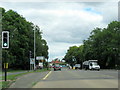
Davies Road junction, Evesham
Looking north towards the town centre on Cheltenham Road.
Image: © Jonathan Billinger
Taken: 18 Sep 2009
0.05 miles
4
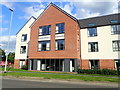
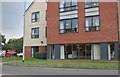
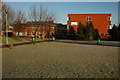
Austen Court Care Home
Providing luxury residential and dementia care. It is situated on the Cheltenham Road.
Image: © Eirian Evans
Taken: 31 Aug 2018
0.06 miles

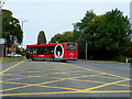
6
Cheltenham Road Evesham at Davies Road junction
Image: © Roy Hughes
Taken: 11 Jul 2020
0.07 miles
7
Entrance to Evesham College
Evesham College opened in the early 1970s and is now merged with Malvern Hills College and known as South Worcestershire College.
Image: © Philip Halling
Taken: 3 Jan 2009
0.07 miles
8
Evesham College
Evesham College opened in the early 1970s and is now merged with Malvern Hills College and known as South Worcestershire College.
Image: © Philip Halling
Taken: 3 Jan 2009
0.08 miles
9
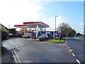
Service station on Cheltenham Road
Petrol 148p.
Diesel 161p.
Image: © JThomas
Taken: 15 Apr 2023
0.16 miles
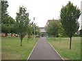
10
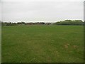
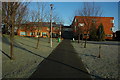
Davies Road open space
An area enclosed by housing on three sides, looking towards Davies Road, with an industrial estate across the road. This space is regularly used by children for various activities and dog walkers. It currently has a fitness trail (a glorified obstacle course) in the far corner.
Image: © David Luther Thomas
Taken: 23 Apr 2007
0.16 miles