IMAGES TAKEN NEAR TO
St. Matthews Close, EVESHAM, WR11 2ES
Introduction
This page details the photographs taken nearby to St. Matthews Close, WR11 2ES by members of the Geograph project.
The Geograph project started in 2005 with the aim of publishing, organising and preserving representative images for every square kilometre of Great Britain, Ireland and the Isle of Man.

There are currently over 7.5m images from over14,400 individuals and you can help contribute to the project by visiting https://www.geograph.org.uk
Image Map
Images are licensed for reuse under creativecommons.org/licenses/by-sa/2.0
Notes
- Clicking on the map will re-center to the selected point.
- The higher the marker number, the further away the image location is from the centre of the postcode.
Image Listing (18 Images Found)
Images are licensed for reuse under creativecommons.org/licenses/by-sa/2.0
Image
Details
Distance
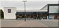
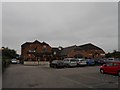
1
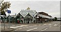
Morrisons supermarket, Evesham
See also https://www.geograph.org.uk/reuse.php?id=3504276 from 2013.
Image: © Mike Dodman
Taken: 13 Oct 2024
0.10 miles
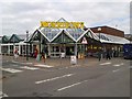
6
Aldi supermarket, Sinclair Retail Park Evesham
Taken late on a Sunday afternoon, after closing time!
Image: © Mike Dodman
Taken: 13 Oct 2024
0.17 miles
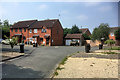
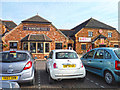
8
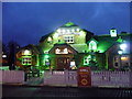
Evesham : Strawberry Field
A pub selling drinks and food throughout the day and evening.
Image: © Lewis Clarke
Taken: 21 Nov 2010
0.17 miles
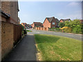
9
Evesham-Strawberry Field
Pub Restaurant on Charity Crescent.
Image: © Ian Rob
Taken: 23 Sep 2013
0.17 miles
10
Evesham : Strawberry Field
Strawberry Field, a pub and restaurant in Evesham.
Image: © Lewis Clarke
Taken: 4 May 2014
0.17 miles