IMAGES TAKEN NEAR TO
Ash Grove, EVESHAM, WR11 1XN
Introduction
This page details the photographs taken nearby to Ash Grove, WR11 1XN by members of the Geograph project.
The Geograph project started in 2005 with the aim of publishing, organising and preserving representative images for every square kilometre of Great Britain, Ireland and the Isle of Man.

There are currently over 7.5m images from over14,400 individuals and you can help contribute to the project by visiting https://www.geograph.org.uk
Image Map (Loading...)


Getting Data...Please wait
Leaflet Map data © OpenStreetMap
Images are licensed for reuse under creativecommons.org/licenses/by-sa/2.0
Notes
- Clicking on the map will re-center to the selected point.
- The higher the marker number, the further away the image location is from the centre of the postcode.
Image Listing (7 Images Found)
Images are licensed for reuse under creativecommons.org/licenses/by-sa/2.0
Image
Details
Distance
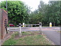
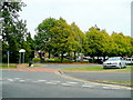
2
The way to town, Evesham
From Davies Road, through the houses.
Image: © Liz Stone
Taken: 21 Jul 2011
0.06 miles
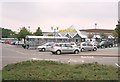
3
B&Q Evesham
The B&Q warehouse at Evesham, one of a number of DIY and other outlets in the area.
Image: © Dave Bushell
Taken: 5 Sep 2005
0.07 miles
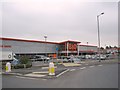
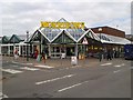
4
Morrison's Supermarket
One of four supermarkets in this small town
Image: © Dave Bushell
Taken: 5 Sep 2005
0.07 miles
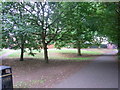
5
Vale of Evesham School
The Vale of Evesham School, which is administered by the Local Authority of Worcestershire, opened in 1969 to cater for the needs of young people with learning difficulties. It still does - successfully.
Image: © Jonathan Billinger
Taken: 18 Sep 2009
0.17 miles
7
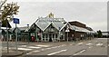
Morrisons supermarket, Evesham
See also https://www.geograph.org.uk/reuse.php?id=3504276 from 2013.
Image: © Mike Dodman
Taken: 13 Oct 2024
0.25 miles