IMAGES TAKEN NEAR TO
Fairfield Road, EVESHAM, WR11 1HL
Introduction
This page details the photographs taken nearby to Fairfield Road, WR11 1HL by members of the Geograph project.
The Geograph project started in 2005 with the aim of publishing, organising and preserving representative images for every square kilometre of Great Britain, Ireland and the Isle of Man.

There are currently over 7.5m images from over14,400 individuals and you can help contribute to the project by visiting https://www.geograph.org.uk
Image Map
Images are licensed for reuse under creativecommons.org/licenses/by-sa/2.0
Notes
- Clicking on the map will re-center to the selected point.
- The higher the marker number, the further away the image location is from the centre of the postcode.
Image Listing (7 Images Found)
Images are licensed for reuse under creativecommons.org/licenses/by-sa/2.0
Image
Details
Distance
1
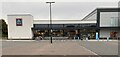
Aldi supermarket, Sinclair Retail Park Evesham
Taken late on a Sunday afternoon, after closing time!
Image: © Mike Dodman
Taken: 13 Oct 2024
0.19 miles
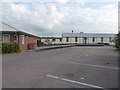
2
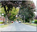
Fairfield Road, Evesham
Mid-twentieth century housing to the south of the town centre.
Nice mature maples line this busy road which leads to several schools.
Image: © Jonathan Billinger
Taken: 18 Sep 2009
0.21 miles
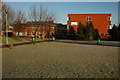
3
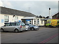
Evesham Community Hospital
The porch on the left is the entrance to the minor injuries unit while the ambulance is in front of the main entrance. One of two metal chimneys is visible. There appears to be no external approach to these two boiler houses. The hospital is very hard to photograph and is best appreciated on the aerial view.
The site has a long history and started life as a workhouse in 1837 and later extensions were built. There are only two building left from the earlier phase. The current hospital was built in 1939 as an Emergency Medical Scheme (EMS) hospital and was taken over by the RAF between 1940 and 1946 for treating injured airmen. It is now a community hospital administered by Worcestershire Health and Care Trust. Other WWII hospitals in Worcestershire were to be found at Bromsgrove and Ronkswood, Worcester and I remember both of those. I had never been to Evesham and hadn't realised its history.
Image: © Chris Allen
Taken: 13 Jul 2019
0.22 miles
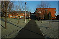
4
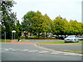
Vale of Evesham School
The Vale of Evesham School, which is administered by the Local Authority of Worcestershire, opened in 1969 to cater for the needs of young people with learning difficulties. It still does - successfully.
Image: © Jonathan Billinger
Taken: 18 Sep 2009
0.22 miles
5
Evesham Community Hospital
A 1939 built Emergency Medical Services hospital now a community hospital. Best appreciated from the air. The chimney is one of two.
Image: © Chris Allen
Taken: 13 Jul 2019
0.23 miles
6
Evesham College
Evesham College opened in the early 1970s and is now merged with Malvern Hills College and known as South Worcestershire College.
Image: © Philip Halling
Taken: 3 Jan 2009
0.24 miles
7
Entrance to Evesham College
Evesham College opened in the early 1970s and is now merged with Malvern Hills College and known as South Worcestershire College.
Image: © Philip Halling
Taken: 3 Jan 2009
0.24 miles