IMAGES TAKEN NEAR TO
Church Street, EVESHAM, WR11 1DS
Introduction
This page details the photographs taken nearby to Church Street, WR11 1DS by members of the Geograph project.
The Geograph project started in 2005 with the aim of publishing, organising and preserving representative images for every square kilometre of Great Britain, Ireland and the Isle of Man.

There are currently over 7.5m images from over14,400 individuals and you can help contribute to the project by visiting https://www.geograph.org.uk
Image Map
Images are licensed for reuse under creativecommons.org/licenses/by-sa/2.0
Notes
- Clicking on the map will re-center to the selected point.
- The higher the marker number, the further away the image location is from the centre of the postcode.
Image Listing (184 Images Found)
Images are licensed for reuse under creativecommons.org/licenses/by-sa/2.0
Image
Details
Distance
1
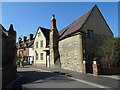
The former the Manor of Bengeworth
The remains of the former the Manor of Bengeworth is reputed to be the oldest building in Bengeworth. The manor of Bengeworth was once held by King Canute Image
Image: © Philip Halling
Taken: 4 Apr 2021
0.01 miles
3
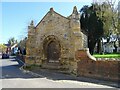
Porch of the Old St Peter's church
All that remains of the medieval St Peter's church is this porch, the church was demolished in 1870. The site is a scheduled monument https://historicengland.org.uk/listing/the-list/list-entry/1005299
Image: © Philip Halling
Taken: 4 Apr 2021
0.01 miles
4
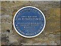
Blue plaque, Old St Peter's church
Blue plaque on the porch of the Old St Peter's church in Bengeworth.
Image: © Philip Halling
Taken: 4 Apr 2021
0.01 miles
5
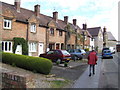
Row of town cottages in Church Street, Bengeworth, Evesham
Image: © Jonathan Billinger
Taken: 22 Jul 2007
0.02 miles
6
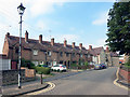
Terrace in Church Street
Part of a pleasant small neighbourhood centred around a green.
Image: © Des Blenkinsopp
Taken: 14 Sep 2016
0.02 miles
7
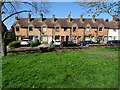
Houses on Church Street, Bengeworth
These houses on Church Street overlook the site of the demolished St Peters church in Bengeworth. They are reminiscent of almshouses.
Image: © Philip Halling
Taken: 4 Apr 2021
0.02 miles
8
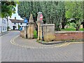
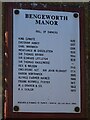
Entrance Gates to Churchyard
Entrance to the old Burial ground on Church Street, at the site of the old medieval church of St. Peter's of Bengeworth Parish. The medieval church was replaced by a new church erected in 1872, on Port Street. Only the porch of the medieval church remains. The wall to the right of these gateposts has an Ordnance Survey bench mark.
Image
Image: © V1ncenze
Taken: 25 May 2021
0.02 miles
9
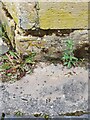
Ordnance Survey Bench Mark
This mark is located on a wall to the old Church burial grounds. These marks were used by Ordnance Survey for mapping purposes.
Image
Image: © V1ncenze
Taken: 25 May 2021
0.02 miles
10
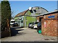
Corrugated iron building
Corrugated iron building in Bengeworth. The building appears as though it needs some attention, at least a coat of paint. The name plate beside the satellite dishes reads 'Carpet Warehouse'.
Image: © Philip Halling
Taken: 4 Apr 2021
0.02 miles