IMAGES TAKEN NEAR TO
Queen Elizabeth Drive, PERSHORE, WR10 9SB
Introduction
This page details the photographs taken nearby to Queen Elizabeth Drive, WR10 9SB by members of the Geograph project.
The Geograph project started in 2005 with the aim of publishing, organising and preserving representative images for every square kilometre of Great Britain, Ireland and the Isle of Man.

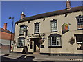
There are currently over 7.5m images from over14,400 individuals and you can help contribute to the project by visiting https://www.geograph.org.uk
Image Map (Loading...)


Getting Data...Please wait
Leaflet Map data © OpenStreetMap
Images are licensed for reuse under creativecommons.org/licenses/by-sa/2.0
Notes
- Clicking on the map will re-center to the selected point.
- The higher the marker number, the further away the image location is from the centre of the postcode.
Image Listing (184 Images Found)
Images are licensed for reuse under creativecommons.org/licenses/by-sa/2.0
Image
Details
Distance
1
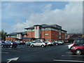
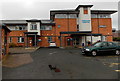
Pershore Hospital
The new Pershore Hospital which was opened by H.R.H Duchess of Gloucester on the 20th May 2007. This is a state of the art facility which replaces the cottage hospital.
Image: © Derek Bradley
Taken: 20 Sep 2007
0.01 miles
2
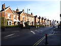
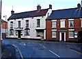
Queen Elizabeth Drive, Pershore
Viewed across Station Road. Queen Elizabeth Drive leads to Pershore hospital,
police station, civic centre and Wychavon District Council offices.
Image: © Jaggery
Taken: 16 Nov 2014
0.04 miles
3
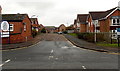
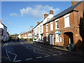
This way to the police station, hospital and council offices, Pershore
The path from High Street leads to Queen Elizabeth Drive. The edge of the Pickled Plum pub http://www.geograph.org.uk/photo/4249197 (formerly The Plough Inn) is on the right.
Image: © Jaggery
Taken: 16 Nov 2014
0.05 miles
4
Pershore Hospital
Worcestershire Health & Care NHS Trust hospital in Queen Elizabeth House, Queen Elizabeth Drive, Pershore.
Image: © Jaggery
Taken: 16 Nov 2014
0.05 miles
5
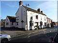
The Pickled Plum, High Street, Pershore
Pershore is famous for its plums and have a plum festival every year.
Image: © Jeff Gogarty
Taken: 28 Jan 2020
0.06 miles
6
The Pickled Plum, Pershore
Formerly named The Plough Inn, http://www.geograph.org.uk/photo/2131266 the pub's new name is one of several in Pershore that include the word plum. Pershore is famous for the many plums grown locally. Every August, the town holds a Plum Festival which celebrates its fruit-growing heritage.
Image: © Jaggery
Taken: 16 Nov 2014
0.06 miles
7
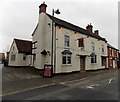
The Plough Inn, 135 High Street
Situated towards the western end of the High Street, this is one of Pershore's many surviving inns and pubs. The recessed area on the right looks as if it might at one time have been the street entrance to a passageway to the back of the building; possibly for horses? The inn does not seem to have a traditional sign. Photograph taken from Priest Lane opposite.
Image: © P L Chadwick
Taken: 26 Nov 2009
0.07 miles
8
Pershore High Street heading out of town
Image: © Jeff Gogarty
Taken: 28 Jan 2020
0.07 miles