IMAGES TAKEN NEAR TO
Owletts Lane, PERSHORE, WR10 3PB
Introduction
This page details the photographs taken nearby to Owletts Lane, WR10 3PB by members of the Geograph project.
The Geograph project started in 2005 with the aim of publishing, organising and preserving representative images for every square kilometre of Great Britain, Ireland and the Isle of Man.

There are currently over 7.5m images from over14,400 individuals and you can help contribute to the project by visiting https://www.geograph.org.uk
Image Map
Images are licensed for reuse under creativecommons.org/licenses/by-sa/2.0
Notes
- Clicking on the map will re-center to the selected point.
- The higher the marker number, the further away the image location is from the centre of the postcode.
Image Listing (9 Images Found)
Images are licensed for reuse under creativecommons.org/licenses/by-sa/2.0
Image
Details
Distance
4
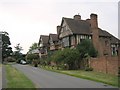
Wick Manor
A Tudor manor house partially rebuilt in the twentieth century, looking west
Image: © Dave Bushell
Taken: 31 Aug 2005
0.19 miles
5
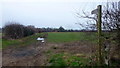
Footpath to Wick
Arable land on the Avon floodplain north of Wick.
Image: © Jonathan Billinger
Taken: 2 Feb 2015
0.20 miles
6
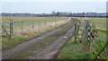
Farm track and a flock of sheep
The Avon floodplain at Wick.
Image: © Jonathan Billinger
Taken: 2 Feb 2015
0.20 miles
7
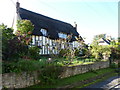
The Oak Cottage, Main Street, Wick, Pershore
Image: © Jeff Gogarty
Taken: 26 Sep 2015
0.22 miles
8
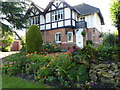
Half-timbered house, Main Street, Wick, Pershore
With a very nice garden for late September
Image: © Jeff Gogarty
Taken: 26 Sep 2015
0.24 miles
9
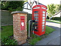
When both mail and telephones were royal
On the Main Street, Wick, near Pershore, Worcestershire
Image: © Jeff Gogarty
Taken: 26 Sep 2015
0.25 miles