IMAGES TAKEN NEAR TO
Smokey Lane, PERSHORE, WR10 3NF
Introduction
This page details the photographs taken nearby to Smokey Lane, WR10 3NF by members of the Geograph project.
The Geograph project started in 2005 with the aim of publishing, organising and preserving representative images for every square kilometre of Great Britain, Ireland and the Isle of Man.

There are currently over 7.5m images from over14,400 individuals and you can help contribute to the project by visiting https://www.geograph.org.uk
Image Map (Loading...)


Getting Data...Please wait
Leaflet Map data © OpenStreetMap
Images are licensed for reuse under creativecommons.org/licenses/by-sa/2.0
Notes
- Clicking on the map will re-center to the selected point.
- The higher the marker number, the further away the image location is from the centre of the postcode.
Image Listing (10 Images Found)
Images are licensed for reuse under creativecommons.org/licenses/by-sa/2.0
Image
Details
Distance
1
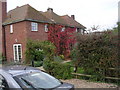
Cropvale Farm, Cropthorne
A working farm at which the farmer's wife has diversified into Bed and Breakfast in the part of the farm visible in this photograph.
Image: © Bill Johnson
Taken: 14 Oct 2007
0.03 miles
2
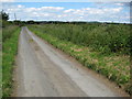
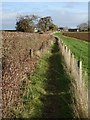
Smokey Lane, Cropthorne
View northwards up Smokey Lane in Cropthorne.
Image: © Philip Halling
Taken: 15 Jun 2008
0.04 miles
3
Cropvale Farm
Cropvale Farm on Smokey Lane viewed from the south.
Image: © Philip Halling
Taken: 22 Dec 2018
0.10 miles
4
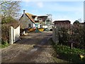
Old Smokey Farm
Old Smokey Farm undergoing redevelopment with some of the house under scaffolding.
Image: © Philip Halling
Taken: 22 Dec 2018
0.14 miles
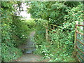
5
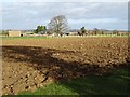
Footpath near Smokey Farm
Footpath approaching Smokey Farm to the south of Cropthorne.
Image: © Philip Halling
Taken: 22 Dec 2018
0.18 miles
6
Looking towards Bredon Hill from Cropthorne
Image: © Bill Johnson
Taken: 14 Oct 2007
0.19 miles
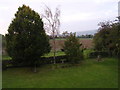
8

Field shelter with rack and manger
Below Cropvale Farm, Cropthorne.
Image: © Liz Stone
Taken: 27 Sep 2011
0.22 miles
9

A corner on Wychavon Way
View to field shelter from below Cropvale Farm.
Image: © Liz Stone
Taken: 27 Sep 2011
0.22 miles
10
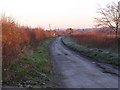
Smokey Lane, Cropthorne
Essentially a farm track leading to Smokey Farm.
Taken on a cold and frosty morning looking north towards the junction with the Evesham/Pershore Road.
Image: © Bill Johnson
Taken: 13 Dec 2007
0.25 miles