IMAGES TAKEN NEAR TO
Endon, PERSHORE, WR10 3JS
Introduction
This page details the photographs taken nearby to WR10 3JS by members of the Geograph project.
The Geograph project started in 2005 with the aim of publishing, organising and preserving representative images for every square kilometre of Great Britain, Ireland and the Isle of Man.

There are currently over 7.5m images from over14,400 individuals and you can help contribute to the project by visiting https://www.geograph.org.uk
Image Map (Loading...)


Getting Data...Please wait
Leaflet Map data © OpenStreetMap
Images are licensed for reuse under creativecommons.org/licenses/by-sa/2.0
Notes
- Clicking on the map will re-center to the selected point.
- The higher the marker number, the further away the image location is from the centre of the postcode.
Image Listing (7 Images Found)
Images are licensed for reuse under creativecommons.org/licenses/by-sa/2.0
Image
Details
Distance
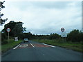
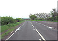
3
B4084 towards Wick and Pershore
Road was demoted from A44 a few years ago.
Image: © Jonathan Billinger
Taken: 2 Feb 2015
0.17 miles
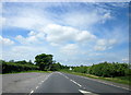
6
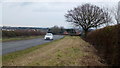
B4084 towards Evesham
Road was demoted from A44 some years ago.
Image: © Jonathan Billinger
Taken: 2 Feb 2015
0.24 miles
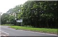
7
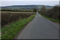
Road to Little Comberton
Road from Wick and B4084 to Little Comberton which can be seen in the middle distance, Bredon Hill is in the background.
Image: © Philip Halling
Taken: 24 Mar 2008
0.24 miles