IMAGES TAKEN NEAR TO
Hill Lane, PERSHORE, WR10 3JB
Introduction
This page details the photographs taken nearby to Hill Lane, WR10 3JB by members of the Geograph project.
The Geograph project started in 2005 with the aim of publishing, organising and preserving representative images for every square kilometre of Great Britain, Ireland and the Isle of Man.

There are currently over 7.5m images from over14,400 individuals and you can help contribute to the project by visiting https://www.geograph.org.uk
Image Map
Images are licensed for reuse under creativecommons.org/licenses/by-sa/2.0
Notes
- Clicking on the map will re-center to the selected point.
- The higher the marker number, the further away the image location is from the centre of the postcode.
Image Listing (8 Images Found)
Images are licensed for reuse under creativecommons.org/licenses/by-sa/2.0
Image
Details
Distance
1
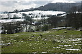
Bredon Hill above Elmley Castle
Snow on the slopes of Bredon Hill above the village of Elmley Castle. Lodge Farm can be seen through the trees.
Image: © Philip Halling
Taken: 6 Apr 2008
0.07 miles
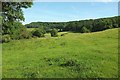
2
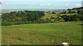
Castle Hill, Elmley Castle
A view from bridleway EC 506 of the hill where there is a "medieval ringwork and bailey located within two Iron Age hillforts" https://www.historicengland.org.uk/listing/the-list/list-entry/1005279 . "The ringwork was constructed by Robert Despenser about 1080 and the bailey was added between 1130 and 1140. In 1317 Hugh le Despenser was ordered to fortify the castle and to garrison it with twenty footmen. In 1321 Elmley Castle was taken by rebel barons under Humphrey de Bohun, Earl of Hereford, and suffered considerable damage". Philip Halling's photos at http://www.geograph.org.uk/search.php?i=73505762 show more details, including an aerial shot.
Beyond is the Vale of Evesham.
Image: © Derek Harper
Taken: 1 Jul 2017
0.21 miles
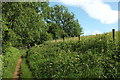
3
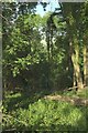
Long Plantation
Looking down through the wood from the Wychavon Way. You can tell there's a tremendous view somewhere there, but you can't really see it. Image] looks right from here.
Image: © Derek Harper
Taken: 1 Jul 2017
0.21 miles
4
Looking into Long Plantation
The Vale of Evesham can be discerned between the trees.
Image: © Jonathan Thacker
Taken: 19 Nov 2013
0.24 miles
5
Wychavon Way beside Long Plantation #2
From where Image] was taken, looking right, as bridleway EC 511 climbs but still has no view northeastwards.
Image: © Derek Harper
Taken: 1 Jul 2017
0.24 miles
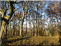
6
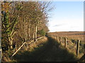
Alongside Long Plantation
The bridleway runs just below the ridge of Bredon Hill.
Image: © Jonathan Thacker
Taken: 19 Nov 2013
0.24 miles
7
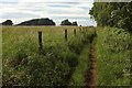
Wychavon Way beside Long Plantation #3
Bridleway EC 511 running above the wood with isolated patches of woodland ahead.
Image: © Derek Harper
Taken: 1 Jul 2017
0.25 miles
8
Slopes of Bredon Hill
From the gate shown in Image], looking left along the hillside, again with Long Plantation along the crest of the slope. Only the first 40 metres of this view are in square. The barn is near Lodge Farm.
Image: © Derek Harper
Taken: 1 Jul 2017
0.25 miles